

DEVELOPING: A major winter storm threatens the Cumberland Plateau region
Heavy snow is possible from Friday night into Sunday


A major winter storm is anticipated across much of Tennessee this weekend, Jan. 24-25. Frequent updates to published information are expected over the next several days. This story will be updated with that new information, so check back frequently for the latest.
Winter Storm Warning issued
Friday, Jan. 23 - 10:42 a.m.
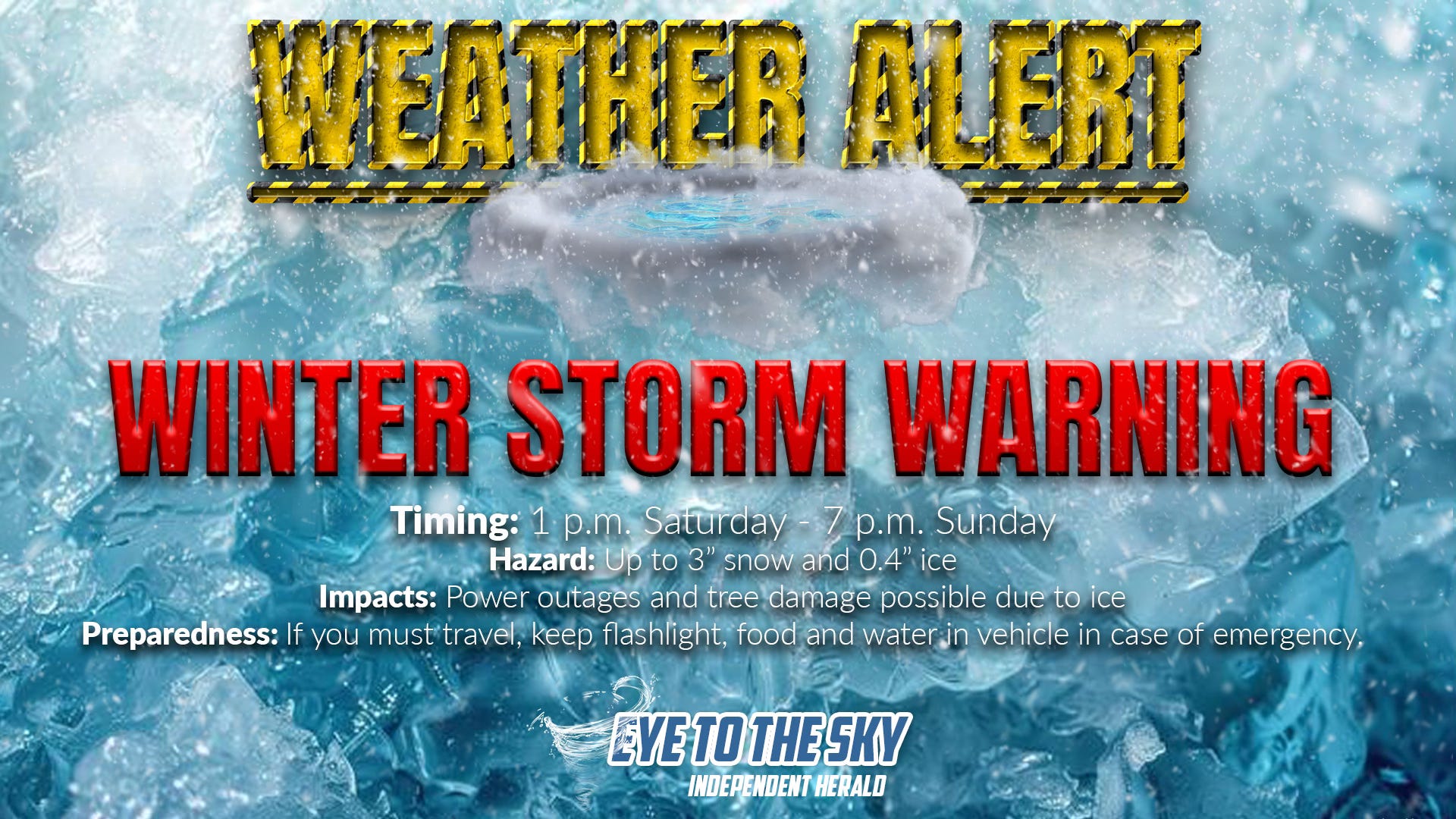
The National Weather Service has issued a Winter Storm Warning for Scott County and the rest of the northern Cumberland Plateau region from 1 p.m. Saturday until 7 p.m. Sunday. In the storm warning, the NWS says that up to three inches of snow and four-tenths of an inch of ice are possible. The agency says that tree damage and power outages are likely, and that travel may become nearly impossible.
The Winter Storm Warning is in effect for most of East Tennessee, except for valley locations. For the valley locations, an Ice Storm Warning has been issued for up to half an inch of ice.
Key model continues to trend downward
Thursday, Jan. 22 - 10:08 a.m.
The latest run of the National Blend of Models — a key forecasting tool employed by the National Weather Service — reduces this weekend’s projected snow accumulations across Scott County to just two to three inches.
Twenty-four hours ago, the NBM was projecting seven inches of snow across Scott County, and 48 hours ago was projecting 10 to 12 inches of snow.
Additionally, the NBM now projects that the temperature will reach 40° in Scott County Sunday afternoon. Twenty-four hours ago, it projected the temperature to remain slightly below freezing throughout the day Sunday.
Models have steadily trended further north with a storm system that will impact the eastern U.S. this weekend, resulting in less snow and warmer temperatures in East Tennessee.
The National Weather Service currently has a Winter Storm Watch in effect for all of East Tennessee from early Saturday morning into Sunday evening, calling for up to six inches of snow. However, it seems likely that the accumulation prediction will be revised downward, perhaps as soon as Thursday afternoon.
NWS revises expectations slightly
Thursday, Jan. 22 - 9:35 a.m.
The National Weather Service’s Morristown weather forecast office has reissued a Winter Storm Watch for East Tennessee. The storm watch is still in effect from 1 a.m. Saturday morning until 7 p.m. Sunday, but has revised accumulation totals. The original storm watch called for 4 to 10 inches of snow north of Knoxville and up to half an inch of ice south of Knoxville. The new storm watch calls for up to 6 inches of snow north and one-tenth to one-quarter of an inch of ice south.
The trends continue to be toward less snow and warmer temperatures with the winter storm. While precipitation is expected to begin as snow on Saturday, it will change to a mix of snow and freezing rain Saturday night and could mix with rain on Sunday. The NWS’s new forecast for the Oneida area calls for a high of 34° on Sunday, as temperatures are now expected to rise above freezing. This is due to the surface low pressure system that will fuel the winter storm traveling through East Tennessee during the day on Sunday, pulling in warmer air from the south.
Once the low pressure system has cleared the area, colder air will crash in, with temperatures falling into the single digits Sunday night and struggling to get out of the teens on Monday. The coldest period is expected to be Monday night, with temperatures near zero.
Evening model runs hold serve
Wednesday, Jan. 21 - 9:06 p.m.
There has been no change in expectations for a weekend winter storm this evening, as the evening model suite came in essentially unchanged from previous runs — the American global model (GFS) showing heavy snow across the northern Cumberland Plateau, and all other models showing a more northern solution that would result in varying but much lesser amounts of snow, along with some sleet, freezing rain, and probably even some plain, ordinary rain.
At this point, forecasters are very uncertain about how to approach this powerful storm system, which promises to deliver devastating impacts somewhere — but where? A Winter Storm Watch remains in effect for Scott County and the rest of East Tennessee from late Friday night through Sunday evening, for 4 to 10 inches of snow. In fact, all of Tennessee and Kentucky are under a Winter Storm Watch, along with a large swath of the rest of the country.
The overnight model suite is just beginning to run, and will continue for the next several hours. As a general rule, this run — called the 0z run — is the most accurate run of the day, because it ingests the most new data of any of the runs in a given day.
Coldest air of the season expected
Wednesday, Jan. 21 • 6:28 p.m.
It’s going to be quite cold after this weekend’s winter storm winds down. Temperatures are likely to moderate to just above freezing on Sunday, but cold air will crash in behind the departing storm system. The National Weather Service is currently forecasting a low of -1° in Oneida Monday night. The last time a subzero temperature reading was recorded in Oneida was Jan. 22, 2024, when the temperature dropped to -7°.
Updated snow accumulation forecast
Wednesday, Jan. 21 • 6:24 p.m.
The National Weather Service’s Nashville weather forecast office has reissued its Winter Storm Watch for Middle Tennessee, and calls for “total snow accumulations over six inches” possible north of Interstate 40. This is in line with the Winter Storm Watch issued for East Tennessee by the NWS’s Morristown weather forecast office earlier today, calling for four to 10 inches of snow north of Knoxville.
Latest thoughts from National Weather Service
Wednesday, Jan. 21 • 3:19 p.m.
From a forecast discussion published this afternoon by the National Weather Service’s Morristown weather forecast office: “I can’t stress enough that the forecast for this weekend continues to have quite a bit of uncertainty associated with it. I also cannot stress enough that if the worst case scenario unfolds, the impacts of this storm are going to be quite bad.”
The discussion goes on to state: “If the northward/warmer trend continues, then we could see snowfall totals in our northern areas continue to dwindle, and may also mean that a sizable portion of our forecast area transitions to an all rain event at some point Saturday evening. Whether the northward trend continues, abates, or whether there’s a reversion to a colder, more southern track, remains an unknown. I would say the odds do not favor a southern/colder adjustment based on trends in the upper level pattern over the CONUS, but we just don’t know.”
Wednesday afternoon model suite is complete
Wednesday, Jan. 21 • 1:04 p.m.
Now that the European global (ECMWF) has run, the midday model suite is all in, and it can be said with certainty that the trend continues of taking the weekend storm system much further north than was originally anticipated.
Rather than traveling east of the Appalachians, through the Carolinas, the low pressure system now looks to travel up the west side of the Appalachians, across Tennessee. This will shift the heaviest snow far north of our area, while increasing the threat of sleet and freezing rain for our area, with only light snow accumulations. Additionally, it will allow much warmer air to be pulled into the region. There’s now a real chance that the northern plateau region will warm to above freezing Sunday afternoon, as the core of the low pressure system passes through the region.
In other words, this is a completely different storm system than was anticipated as recently as 24 hours ago. A Winter Storm Watch remains in effect by the National Weather Service, calling for 4 to 10 inches of snow in Scott County. However, it will be surprising if this watch isn’t changed pretty significantly.
The only model of note that still shows significant snow accumulation across the northern Cumberland Plateau is the American global (GFS). However, its ensemble run is creeping northward, as it trends toward the other global members. It does appear the storm system’s northward jog on the models has stopped, at least for now, so perhaps forecasters can start to formulate more specific forecasts soon.
Winter Storm Watch issued for East Tennessee
Wednesday, Jan. 21 • 12:34 p.m.
The National Weather Service’s weather forecast office in Morristown has issued a Winter Storm Watch for all of East Tennessee, including Scott, Campbell and Morgan counties, from 1 a.m. Saturday morning through 7 p.m. Sunday morning. The storm watch calls for 4 to 10 inches of snow, primarily north of Knoxville, and up to one-half inch of ice, primarily south of Knoxville (specifically, a line from Crossville to Tellico Plains).
Importantly, the storm watch includes this text: “This is a complicated forecast and details regarding the location of heaviest snowfall and freezing rain totals remain uncertain. Significant changes could occur in the coming days so please continue to monitor future forecasts."
That text is likely included because models are currently trending away from the specific scenarios laid out in the storm watch — perhaps meaning NWS meteorologists don’t want to jump on those changes this soon, but need to account for the idea.
Additionally, a Winter Storm Watch has been issued for McCreary County and the rest of southeastern Kentucky by the NWS weather forecast office at Jackson, Ky. from 7 a.m. Saturday through 7 a.m. Monday. The storm watch does not include accumulation specifics, but says that periods of moderate to heavy snow are forecast, along with the possibility of a wintry mix of snow, sleet and freezing rain. “Travel could be very difficult to impossible,” the agency said in the storm watch.
Movement away from snowstorm potential continues
Wednesday, Jan. 21 • 11:41 a.m.
The midday model suite is trickling in, and most major models continue to trend away from the idea of a major weekend snowstorm on the northern Cumberland Plateau, continuing the trend of placing the storm system further north. That northward movement, which was first picked up on by the European global model (ECMWF) last night, shifts the heavy snow accumulation north across the Ohio Valley, while also shifting the potential for ice or sleet further north across parts of Tennessee.
Among the models, the American global (GFS) remains the southernmost solution, continuing to paint heavy snow across the northern plateau region. However, this particular model has been very unreliable this winter and is basically an outlier among the various global models. The only other model in its corner, as of last night, was the ICON. But that model has also shifted further north today. The National Blend of Models continues to show Winter Storm Warning-criteria snow accumulation across the northern plateau, perhaps because it is taking the GFS into account, but it is also shifting northward with time. Further, the GFS Ensemble is further north with heavy snow than the operational run, keeping the significant accumulations mostly across Kentucky. At this point, there is very little reason to think that the heaviest snowfall won’t be across Kentucky or even further north than that.
Models show major changes
Wednesday, Jan. 21 • 9:30 a.m.
Less than 18 hours ago, most models were showing significant accumulating snows for the northern Cumberland Plateau region. This morning, that has changed drastically. Now, most models have shifted the significant snow accumulation north into the lower Midwest, including Kentucky and southern portions of Illinois, Indiana and Ohio, while increasing the potential for freezing rain or sleet here in Tennessee. Areas of the Deep South that were looking at potential for a crippling ice storm yesterday now look like they might escape that nightmare scenario. However, the latest model trends means there is an increasing risk of an ice storm in parts of Tennessee, including the northern plateau region.
For now, the National Weather Service’s forecasts have remained mostly unchanged, though NWS-Morristown has introduced the wording “wintry mix” to the forecast for the Oneida area. This morning’s forecast discussion from NWS-Morristown reflects the massive uncertainty: "The beginning and end of the event keep shifting. The degree of cold air, strength/location of the Arctic high isn`t entirely known which could affect the rain snow line. The axis of heaviest liquid precipitation could be anywhere from GA to across our region, or to our north. Just how much liquid precipitation keeps changing as well. Another localized type feature to watch out for is the inverted trough and just how strong that could get paired with the strength and location of the surface high. As newer model runs have populated in the last couple of hours such as the Canadian and UKMET, consensus is trending towards warmer air aloft shifting further north, possibly to the TN and VA state line, but this will need close monitoring. Needless to say, rain, freezing rain, and snowfall amounts will likely increase or decrease once we get closer and the aforementioned features come more in line. There is still too much uncertainty to say for certain where the changeover could be."
The bottom line: We had excellent model consistency yesterday. Today, we have very poor model consistency. Overall, the threat of significant snow accumulations here in our area are quickly decreasing, while the threat of freezing rain is increasing. It is a very fluid and uncertain situation at this point. Here’s more from our Facebook discussion this morning.
Winter storm watches expand eastward
Wednesday, Jan. 21 • 6:05 a.m.
Winter Storm Watches have been posted for West Tennessee and Middle Tennessee by the National Weather Service offices in Memphis and Nashville. The Winter Storm Watch in Middle Tennessee extends as far east as Fentress and Pickett counties, which are covered by the NWS-Nashville office. Scott County, Morgan County and Campbell County are covered by the NWS office in Morristown, along with the rest of East Tennessee.
First winter storm watches go up
Tuesday, Jan. 20 • 3:07 p.m.
The first Winter Storm Watches associated with this weekend’s winter storm have been issued by National Weather Service offices to the west of Tennessee. Winter storm watches are in effect for northeast Texas and northern Louisiana, along with much of Oklahoma and Arkansas. Expect these watches to expand eastward over the next 24 hours, perhaps to include East Tennessee.
The storm is expected to begin on Friday, bringing heavy snow on its north side and significant amounts of freezing rain further south. In Arkansas, the NWS office in Little Rock is forecasting more than four inches of snow.
The original story follows…
A major winter storm appears to be taking shape for this weekend, with significant and disruptive snow accumulations possible across the northern Cumberland Plateau region. Further south, a crippling ice storm is possible across portions of Alabama and Georgia.
A low pressure system on the southern branch of the jet stream is expected to pull copious amounts of moisture north from the Gulf of Mexico, clashing with a deep surge of arctic air that will settle over the region from the northwest. Snow showers are expected to begin Friday night, then intensify Saturday and Saturday night before tapering off Sunday.
The National Weather Service is using cautious language, given that the onset of the storm is still more than 72 hours away. However, the NWS forecast for Oneida currently calls for a 50% chance of snow showers Friday night with a low of 15°, an 80% chance of snow with a high of 22° on Saturday, and a 90% chance of snow with a low of 16° Saturday night. The NWS’s forecast notes that “snow could be heavy at times” both Saturday and Saturday night. There’s a 50% chance of snow showers on Sunday.
In a Tuesday morning forecast discussion, the NWS’s Morristown weather forecast office, which covers Scott County, cautioned that uncertainty remains around the impending winter storm, but said that “very significant snow accumulations” will be possible in a band somewhere across East Tennessee.
In an afternoon forecast discussion, the agency said that there are two possibilities currently in play: one that would involve a “significant snowfall event” in northern areas, which includes Scott County, with significant icing in southern Tennessee, while the other would result in lighter snow totals further north and heavier amounts along and south of the I-40 corridor.
“At this point in time, it’s difficult to tell which scenario is more likely to play out,” the agency said. “What is pretty clear though is that a highly impactful winter weather event seems set to play out across the southern Appalachian region Saturday and Sunday.”
The NWS added that “power outages will be a distinct possibility.”
The National Blend of Models, a tool used by NWS meteorologists, currently projects the scenario that includes heavier snow further north, painting 10 to 12 inches of snow across the northern Cumberland Plateau region. According to a graphic published by the NWS’s Nashville weather forecast office on Tuesday, the NBM indicates a greater than 60% chance that the northern plateau region will see greater than six inches of snow accumulation.
In its own forecast discussion, NWS-Nashville said that uncertainty remains but its confidence is high in an impactful weekend winter storm.
“Go ahead and make preparations and don’t plan on traveling if you don’t need to,” the agency said. “It is not a simple setup that gives us high confidence in snow or ice amounts. Yes, there are individual models that say a large portion of the area will receive a foot of snow. But, on the flip side, there are models that bring the warm air well into Middle Tennessee which would produce more freezing rain or sleet which would crush the hearts of snow lovers, but still produce significant impacts.”