

Friday Features: A scenic drive up Rock Creek
Plus: The Winter Hiking Challenge visits Angel Falls Overlook, and Scott High construction students tackle a new concession stand

You’re reading Friday Features, a weekly newsletter containing the Independent Herald’s feature stories — that is, stories that aren’t necessarily straight news but that provide an insightful look at our community and its people. If you need to subscribe or update your subscription, please use the option below.
Today’s newsletter is sponsored by First National Bank. Since 1904, First National Bank has been a part of Scott County. First National is local people — just like you. Visit fnboneida.com or call (423) 569-8586.


A drive up Rock Creek to Bell Farm and across Parkers Mountain
Editor’s Note: This is “Sunday Drives,” a new series by the Independent Herald. Consider it a form of the Hiking Challenge that doesn’t require you to leave your vehicle or break a sweat. Over the next several weeks, we’ll take a series of road trips that begin and end in Scott County but that venture out into some surrounding areas that most of us aren’t especially familiar with. These places all have one thing in common: they showcase the spectacular beauty that the North Cumberland region has to offer.

Most of us who grew up in Scott County or have spent a considerable amount of time here are very familiar with the Big South Fork National River & Recreation Area. At 125,000 acres, it’s the fifth-largest national park in the eastern United States. But even among us who’ve lived here most or all of our lives, few are very familiar with the huge national forest that both borders and dwarfs the the BSF in size.
Our first “Sunday Drive” leads us to the Daniel Boone National Forest. Actually, we’ll only be exploring the very southern tip of it. With nearly 710,000 acres sprawled throughout a 2.1 million-acre proclamation boundary, exploring the entire national forest would take literally weeks. But for a day trip that doesn’t take more than a few hours to complete, Rock Creek is a good place to start.
This loop road trip covers a lot of ground — first to Yamacraw, then up Rock Creek and across Parkers Mountain to Pickett State Park. But it’s a little less than 80 miles, requiring just over two hours to drive in its entirety without any stops. Of course, you’ll want to take a few stops along the way, if only for photos, because this is a spectacularly beautiful and peaceful drive.
A Dairy Bar start: You’d ordinarily take KY 92 at Stearns to get to Yamacraw. But we wanted to head a bit further north, into Whitley City, to get things started at the Dairy Bar. It’s perhaps the most unique locally-owned restaurant in McCreary County, a favorite of the locals and residents of surrounding communities alike — including many in Scott County. Located at 198 S. Main Street in Whitley City, it’s been around forever and is open 8 a.m. until 10 p.m. six days a week. It’s actually closed on Sunday, so if you’re truly completing these road trips as Sunday drives, you’re out of luck. As an aside, the Dairy Bar is considered the starting point of the Yamacraw Arrowhead, a motorcycle road trip linking Burnside, Whitley City and Monticello.
To Yamacraw: From the Dairy Bar, head south on Main Street, which is KY 1651. Then take Poplar Springs Road to bypass Stearns, and you’ll reach KY 92 at Kidd’s Grocery. A right turn onto 92 leads you west to Yamacraw.
Yamacraw was once a coal town on the Big South Fork River. It was also known as “Lonesome” when there was a post office operating there. As you might suspect, Yamacraw is an Indian word. The Yamacraw tribe was mostly associated with Georgia, but part of the tribe’s range included Kentucky. In fact, when Kentucky was granted statehood in 1792, the Yamacraw were just one of 20 tribes (along with the Cherokee, Chickasaw, Shawnee and many others) that claimed land in Kentucky.
It wasn’t until the 1880s that coal mining came to Big South Fork Country and changed the region forever. That was largely made possible by the building of the Cincinnati-Southern Railroad, which we know today as the Norfolk-Southern Railroad. Several short-line railroads sprung up to reach the various seams of coal in the region — like the Tennessee Railroad, the Brimstone Railroad and the Oneida & Western Railroad in Scott County. More on old railroads in a moment.
The first sight to see at Yamacraw is the river access point on the east side of the KY 92 bridge. This is a trailhead on the Sheltowee Trace Trail, and you’ll find hikers parked here on just about any nice weather day. The most popular hike from this location is Princess Falls, which is located along Lick Creek. Technically, Yamacraw is located in the Big South Fork National River & Recreation Area, but just barely. This is the northernmost extent of the national park.
Up the River: Across the bridge from the day use area, we turn left onto KY 1363. This is the road to Bell Farm. The two-lane highway parallels the Big South Fork River for a short distance. This part of the BSF is much different from the upper reaches of the river system in Scott County, where it’s known for its whitewater. Its last major hurrah as a whitewater river is the Class IV Devils Jump rapid at the old Blue Heron mining camp. From there, the water slows as the descent lessens, and it eventually succumbs completely to the taming effects of the Wolf Creek Dam and Lake Cumberland. The Big South Fork flows into the Cumberland River at Burnside, Ky. — specifically, at Burnside Island, which is today a state park on the south side of the town.
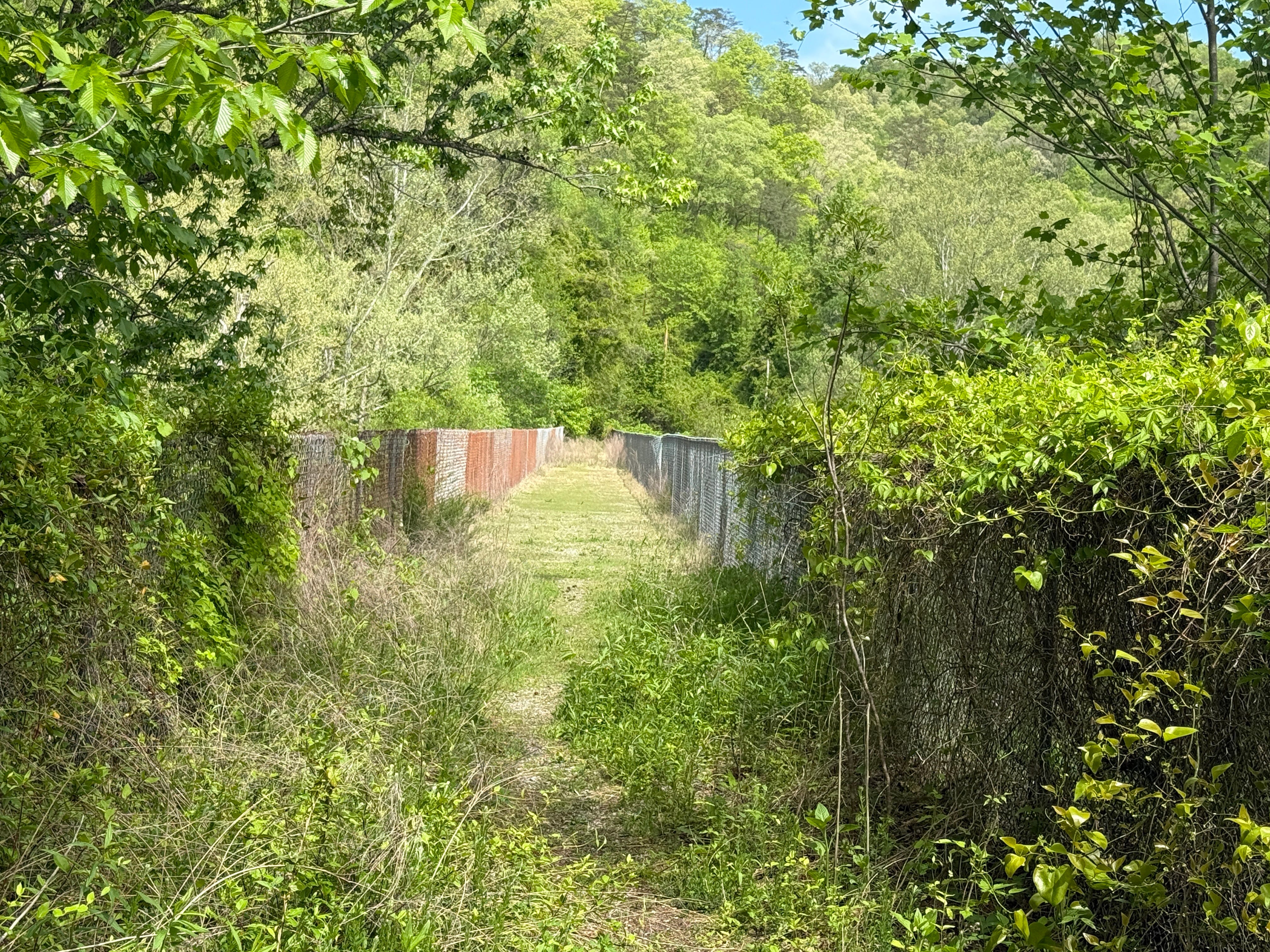
After about a mile, the highway makes a sharp right turn away from the river. There’s a small gravel pull-off to the left, though, and this is an opportunity to stop and observe one of the remnants of the old railroads mentioned previously. The Yamacraw Bridge crosses the BSF River here. It’s long since been abandoned, and years of sediment collecting on the bridge span has allowed grasses and weeds to grow on it.
The Yamacraw Bridge was a bridge on the Kentucky & Tennessee Railroad that was built by the Stearns Coal & Lumber Co. in 1906. The bridge was built by Collier Bridge Company out of Indianapolis. It was used until the last mines closed in the ‘80s, which also marked the end of the coal loading facility at Oz, Ky., the site of which we’ll be driving by on this trip.
Originally, the K&T began at Stearns and traveled to the BSF River by way of Barthell — the route that is today the Big South Fork Scenic Railway. There was a spur to Blue Heron, while the main line turned north along the river through Worley and on to Yamacraw, where it crossed the river on this old bridge and continued to Oz. It originally went as far west as Bell Farm and also included a spur line to Cooperative. In fact, there was once passenger service on the railroad between Bell Farm and Stearns.
One last interesting fact about the K&T: When the railroad switched from steam-powered engines to diesel-powered engines, it learned to drive its “new” Alco S2s from the Tennessee Railroad in Oneida, which was using Alcoa RS1s.
You can still walk onto the old Yamacraw Bridge, and if you do so, you’ll notice the mouth of Rock Creek as it calmly flows into the Big South Fork River almost directly below the bridge. Much of our trip is going to be spent along Rock Creek.
Up the Creek: Back on the road, we continue west on KY 1363, following Rock Creek. In places, you’ll notice the old railroad grade on the left side of the highway. You’ll also note several gated side roads to the right. These once led to the mining operations. Our destination is White Oak Junction, which is where we’ll leave the pavement behind for a while.
White Oak: Today, White Oak Junction is nothing more than a crossroads, where KY 1363, Andy Watson Road and Rock Creek Road all meet. But there was a time when this was a happening place. It even had its own post office until 1949. It was named for a stop on the K&T Railroad, but the trains stopped traveling this far west in about the same time the post office closed. The section of line between White Oak and Bell Farm closed in 1949, and the spur to Cooperative closed in 1950. In 1953, the railroad line was cut back to Oz, a couple of miles east of White Oak Junction.
We’re turning left off KY 1363 onto Rock Creek Road, or Forest Service Road 566. While you can take the paved highway all the way to Bell Farm, we want to take the more scenic route, along the creek itself. Rock Creek Road is gravel, so it isn’t suitable for motorcycles, but it is extremely well-maintained and easily traveled by car.
Rock Creek is a beautiful mountain stream. Yes, this is the same Rock Creek that is featured prominently on the Rock Creek Loop hiking trail in the Big South Fork NRRA much further upstream. Its headwaters are located in Scott and Pickett counties.
Eighteen miles of Rock Creek are maintained as a “Kentucky Wild River,” from the TN-KY line to White Oak Junction. Below White Oak Junction, acid mine drainage pollutes the stream. It was once difficult for anything to live in the water due to the runoff from the old deep mines, but that’s slowly changing thanks to the work of a number of state and federal agencies.
Upstream of White Oak Junction, the U.S. Forest Service stocks rainbow trout into Rock Creek on an annual basis. In fact, Rock Creek is recognized as the most popular trout stream in all of Kentucky. It features a mix of sluggish pools and fast-moving shoals, and smallmouth bass can be found in the stream along with the trout.
There are a number of places to pull off along the route and enjoy the scenery that the stream offers. You’ll likely encounter folks who are fishing, picnicking or even camping along this gravel road through the Daniel Boone National Forest.
Along this eight-mile stretch of gravel road along Rock Creek, there are a few parcels of private land that are embedded within the national forest, so you’ll see an occasional home.
An interesting part of this trip: Several of the families that eventually wound up settling the Big South Fork communities like Station Camp and No Business came from the Rock Creek area. Most famously, Jonathan Blevins — the ancestor of all Blevinses in Scott County today — first settled at Rock Creek before eventually moving further south to Station Camp Creek.
Bell Farm: After eight miles of following Rock Creek through the forest, the route returns to civilization — just barely — at Bell Farm. Today, Bell Farm is nothing more than a campground maintained by the Forest Service for horseback riders. But like all the other map dots in this area, Bell Farm was once a bustling coal and timber town. Later, it was the site of a Civilian Conservation Corps camp in the 1930s.
Parkers Mountain: From Bell Farm, we’re headed to Parkers Mountain. We’ll do so by following Lonesome Creek Road. A short distance from Bell Farm, the road intersects with Fire Road 137, which continues up Rock Creek to the Hemlock Grove picnic area and Great Meadows campground. This is a beautiful drive if you want to take a side trip and continue to explore Rock Creek, but it’s a dead-end road so you’ll eventually have to retrace your drive back to Bell Farm.
Fire Road 564 climbs to the top of Parkers Mountain, which is actually a long ridge between Rock Creek and Lonesome Creek. Much like the roads along Rock Creek, this is a well-maintained gravel road easily suitable for cars and other low-clearance vehicles. There are several overlooks along the ridgetop that look off into the Rock Creek and Lonesome Creek valleys.
The Josiah Terry Grave: Parkers Mountain Road, or Fire Road 564, eventually ends at KY 167, as the trip returns from gravel to pavement. KY 167 becomes TN 154 just a few hundred feet south of the intersection, where the highway enters the northwest corner of Scott County.
At the intersection of Parkers Mountain Road and KY 167, on the west side of the highway, is a small cemetery that includes the grave of Josiah Terry, the first settler of Oneida. Terry was originally from Botetourt County, Va., and moved to the Cumberland Plateau sometime before 1806, along with his brother, Elijah Terry. A plaque outside the Oneida Municipal Services Building pays tribute to Josiah Terry as the town’s first settler. He died in 1868 and was buried here, just north of the TN-KY border.
Pickett State Park: Heading south on the highway, KY 167 becomes TN 154 as it passes through Scott County for a short distance, then enters Pickett County. As it travels through Scott County, it passes briefly through the Big South Fork National River & Recreation Area. Then it enters Pickett State Forest.
A road trip down TN 154 would not be complete without stopping at Pickett State Park, one of Tennessee’s oldest state parks. It was organized by the Civilian Conservation Corps in the 1930s, on land donated by the Stearns Coal & Lumber Co. It is a memorial state park to the CCC, and a statue at its entrance pays tribute to CCC workers.
Pickett State Park includes a small trout lake, which can be paddled by boat, hiking trails, picnic areas and playgrounds for kids.
Just south of the state park on TN 154 you can see the substantial damage caused by the severe thunderstorm that struck the area on Memorial Day weekend in 2024. A swath a couple of hundred yards wide on either side of the highway is now completely devoid of mature trees; all of them were wiped out by the storm’s high winds, which created damage from Pickett State Forest all the way to the Duncan Hollow Road area north of Bandy Creek.
Also south of the state park is the Pogue Creek Canyon State Natural Area. There isn’t much to see from the car, but this is a trailhead for several spectacular hiking trails. It’s also a designated Dark Sky area for stargazers, and there are two solar-powered electric vehicle charging stations that are free to use for EV drivers.
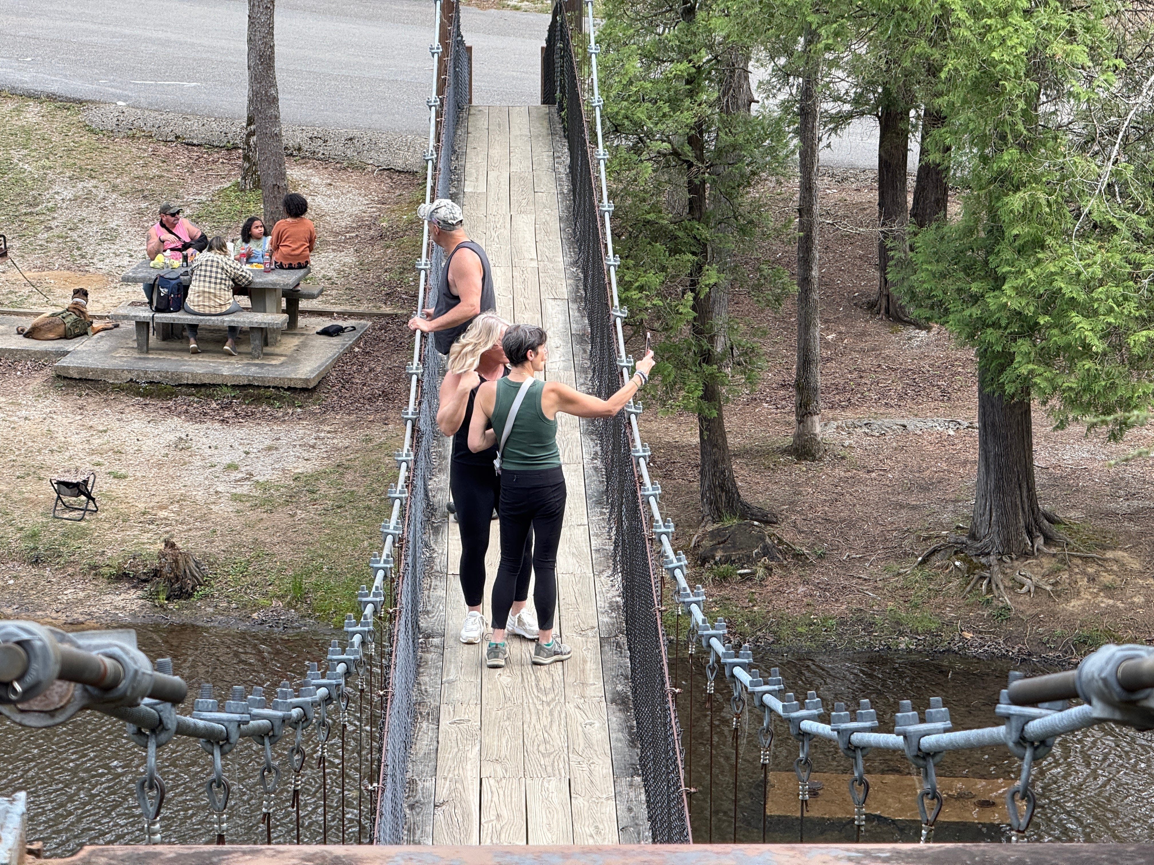
Back home: From Pogue Creek Canyon, it’s a short and leisurely drive along TN 297 through the Big South Fork River gorge at Leatherwood and back to Oneida, completing the 77.3-mile round trip.
Complete Directions: For the sake of planning, we’ll begin and end our road trips at the Oneida Walmart. From Walmart:
• Take U.S. 27 north for 16.8 miles to Whitley City.
• Turn left onto Williamsburg Street at the first traffic light in Whitley City.
• After a tenth of a mile, turn left onto KY 1651. The Dairy Bar is on the right. Continue south on KY 1651 for 1.2 miles.
• Turn right onto Poplar Springs Road and follow it for 1.0 mile until it ends at KY 92.
• Turn right on KY 92 and take it for 4.2 miles to Yamacraw.
• Turn left onto KY 1363 and take it 4.6 miles to White Oak Junction.
• Turn left onto CR 1236/Rock Creek Road and continue 6.7 miles to Bell Farm.
• At Bell Farm, continue on CR 1239 for 1.4 miles.
• Turn left onto Bell Farm/Fidelity/Rock Creek Road and continue two-tenths of a mile, then stay left at the turnoff and continue on Bell Farm/Fidelity/Rock Creek Road for another 1.1 miles.
• The road splits, with the left fork being the road to Hemlock Grove and Great Meadows. Stay right on Bell Farm/Lonesome Creek Road and begin climbing the mountain.
• After nine-tenths of a mile, the road splits again. Stay left onto Parkers Mountain/Fire Road 564. Taking the right fork would lead you to Mt. Pisgah, Ky.
• After 5.7 miles, Fire Road 564 reaches KY 167. Turn left onto the highway and follow it 5.3 miles to its intersection with TN 297. Turn left onto TN 297 and continue 27 miles through the Big South Fork and back to Oneida.
Find more photos of this Sunday Drive on our Facebook page.

Ridgeview Behavioral Health Services offers its Mobile Health Clinic at Walmart in Oneida every Monday from 9 a.m. until 3 p.m. (Sponsored content.)
Winter Hiking Challenge: Angel Falls Overlook
Trail: Grand Gap Loop to Angel Falls Overlook
Starting Point: Alford Smith Road
Length: 2.9 miles
Elevation Gain: 322 feet
Difficulty: Easy
It isn’t winter anymore, so it’s almost time to wrap up the Winter Hiking Challenge. We have two hikes remaining, and this week’s will lead us on a short walk to what is perhaps the single most photographed sight in the Big South Fork National River & Recreation Area: Angel Falls Overlook.
There are multiple ways to get to Angel Falls Overlook, but we’re going the shortest route: by way of Alford Smith Road near Bandy Creek.
Angel Falls Overlook is located on the Grand Gap Loop Trail. By itself, Grand Gap is a 6.8-mile loop along the rim of the gorge that encases the Big South Fork River. It’s a nice hike, but not a spectacular one, and it is most popular among mountain bikers these days. So we’re going to bypass the chance to do the entire hike.
On the other hand, the most popular way to access Angel Falls Overlook is to begin at Leatherwood Ford and take the John Muir Trail to the top of the gorge. It’s a beautiful hike, but a strenuous one. More on that later.
To get to the Grand Gap Loop trailhead, travel to Bandy Creek and turn right into the campground. Take a left just past the check-in kiosk, towards the swimming pool. At the pool, the pavement ends. Continue straight onto the gravel road, which is Duncan Hollow Road. As you travel Duncan Hollow Road, you’ll pass two turnoffs — one to the right (Litton Farm Road) and one to the left (Duncan Hollow Bypass). Continue straight on Duncan Hollow Road at both of these turnoffs, until you reach Alford Smith Road, which turns right. Follow Alford Smith Road to its end, where there’s a small parking area.
Alford Smith Road is named for the man who once lived just past where the road now ends. He was the son of John “Hawk” Smith, one of the Big South Fork region’s best-known characters. As you hike the Grand Gap Loop to Angel Falls Overlook, you’ll pass the grave of one of Alford Smith’s sons, baby Archie Smith.
As you reach the end of the road, you’ll notice the hiking trail crossing the road. Once you’ve parked, backtrack slightly on foot, then turn left onto the Grand Gap Loop Trail. You’ll pass an intersection with the Fall Branch Trail almost immediately. Fall Branch Trail leads to the John Litton Farm Loop. Continue along Grand Gap Loop, which loops around the ridge and follows the old Alford Smith Road for a distance before turning down a ridge top towards the gorge.
At the end of that ridge, you’ll emerge at a scenic overlook of Fall Branch. It’s a beautiful view, but don’t be fooled into thinking this is the destination, because Fall Branch Overlook pales in comparison to Angel Falls Overlook.
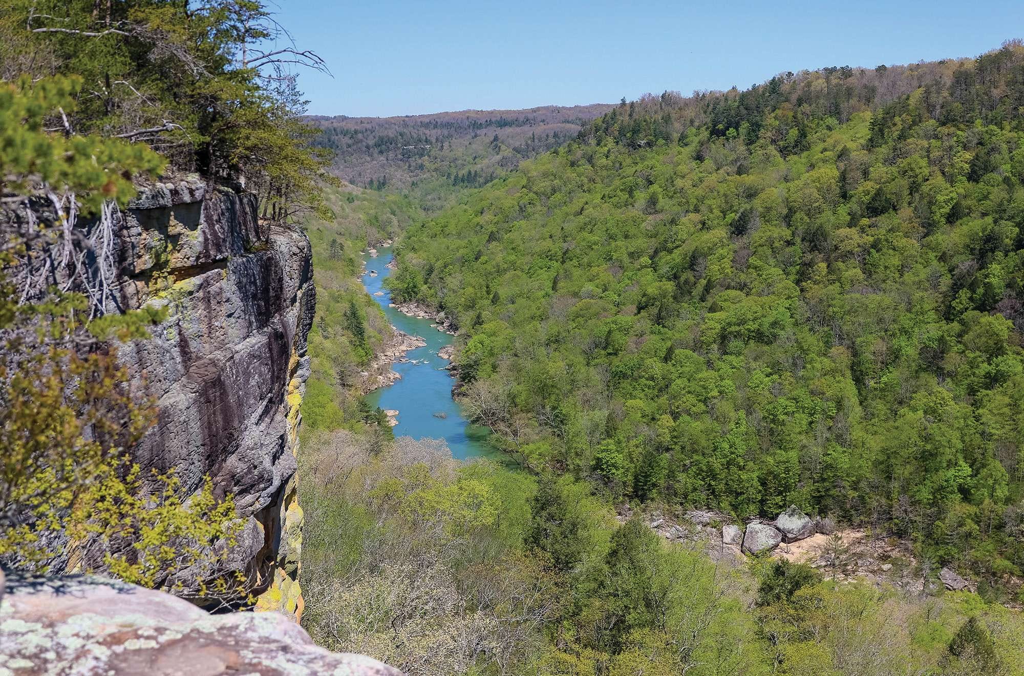
A short distance past Fall Branch Overlook is another trail intersection. This is the John Muir Trail, which leads back to Leatherwood Ford. Beyond the trail intersection, it’s a short, flat walk to Angel Falls Overlook, which is located on an rock outcropping at the mouth of Fall Branch, just above the Big South Fork’s most famous whitewater rapid.
Step over a crack and onto the rock outcropping and enjoy one of the most beautiful views the Big South Fork region has to offer before retracing your steps to the trailhead.
The total length of this hike is 2.9 miles, out and back, with 322 feet of elevation gain. It’s an easy hike.
The Extra Mile: Want something longer? Take the alternate route to Angel Falls Overlook, by starting at Leatherwood Ford. You’ll cross the S.R. 297 bridge on foot, turn down a set of concrete steps on the west side of the bridge, and from there access the John Muir Trail, which follows the river to Fall Branch. At Fall Branch, the trail fords the creek and begins the ascent to the top of the gorge, where it passes through a beautiful canyon-like setting and intersects with Grand Gap Loop Trail. This way is a 5.5-mile hike featuring about 600 feet of elevation gain. It’s a strenuous hike, only because of the climb between Fall Branch and Grand Gap, but it’s well worth the effort.
Remember: Obey the creed — “Leave only footprints; take only memories.”

Students tackle new concession stand project
Editor’s Note: “School Spotlight” is presented by the Scott County School System.
Students in Mr. Jason Jeffers' construction class at Scott High School are taking on a real-world project—building a brand-new concession stand at the school’s football field.
The project, which broke ground earlier this month, is providing students with hands-on experience in carpentry, electrical work, and project planning. Under Jeffers’ guidance, the new facility will be student-built from the ground up. They will have the unique opportunity to learn about the planning and construction of the building. The students are gaining real skills that they can take into the workforce after graduation and are building something that will benefit the school for many years to come.
The current concession stand, a decades-old structure, has struggled to meet the needs of growing crowds that attend events at Scott High School. . The new concession stand facility will be 1,920 square feet and house a spacious new concession stand, bathroom facilities, and a locker room area.
Although there is not a set timeline for the end of the project, Jeffers is hoping to have at least the bathrooms fully functional by the first home football game in the fall. The goal is for the remainder of the facility to be completed by the end of the football season. The new concession stand will accompany the recently installed turf football field. It will enhance the overall game-day experience for fans, players, and the community.
Founded in 1976, the Independent Herald is the Voice of Scott County and Big South Fork Country. We publish newsletters throughout the week: The Daybreaker on Monday morning, Echoes in Time on Tuesday, Threads of Life on Wednesday, The Weekender on Thursday evening, and Friday Features on Friday. You can subscribe or adjust your subscription to choose which newsletters you’d like to receive: