Friday Features: Honey Creek Loop completes Winter Hiking Challenge
Plus: School news and two first for TCAT students
You’re reading Friday Features, a weekly newsletter containing the Independent Herald’s feature stories — that is, stories that aren’t necessarily straight news but that provide an insightful look at our community and its people. This is one of six newsletters we publish each week. You can update your subscription to include as many or as few as you would like to receive. If you need to subscribe, simply enter your email address!
Today’s newsletter is sponsored by First National Bank. Since 1904, First National Bank has been a part of Scott County. First National is local people — just like you. Visit fnboneida.com or call (423) 569-8586.
Hike #10 of 10: Honey Creek Loop


Trail: Honey Creek Loop
Distance: 5.5 miles
Elevation Gain: 853 feet
Starting Point: Honey Creek Trailhead (Honey Creek Road, Robbins • 36.42126, -84.65182)
Difficulty: Strenuous
When it comes to the Big South Fork National River & Recreation Area, there is no trail any more popular than Honey Creek.
In fact, Honey Creek is usually considered one of the best day hikes not just in Tennessee but in the entire eastern United States — the Great Smokey Mountains National Park not withstanding. And this is where we’ll conclude the 2025 Winter Hiking Challenge.
At 5.5 miles in length, Honey Creek is considered the most strenuous hiking trail within the BSF. The National Park Service recommends allowing an hour per mile to complete the hike, and says it performs more wilderness rescues on this trail than any other in the BSF — often because hikers under-estimate how much time it’ll take to complete the trail and wind up stranded in darkness.
With that said, Honey Creek Loop isn’t too daunting. It’s no Angel Falls or Sunset Overlook, but it’s also less strenuous than many of this nation’s best-known hiking trails. If you’re even remotely experienced as a hiker, you can complete this trail without too much difficulty. And what this trail requires in terms of sweat equity, it makes up for in sheer natural beauty. Nowhere else in the Big South Fork compares to the raw beauty found within the Honey Creek gorge.
Honey Creek is especially magical after a heavy rain, when water seems to seep and pour from every crevice in the earth. It’s an alluring hike any time of the year, of course, but it loses some of its luster during dry weather.
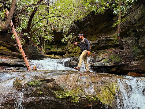
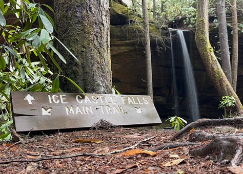
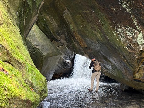
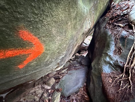
The pictures you see accompanying this story were taken earlier this year, when winter’s thaw was underway. That’s because we scouted this trail early in the hiking challenge before deciding to save it for the very end.
A few things to note about Honey Creek: it should be hiked in a counter-clockwise direction. This isn’t an absolute must, but it makes the trail easier to follow. The trail can be difficult to follow in places because it’s poorly signed and other hikers who have ventured off-trail have beaten down footpaths that simply dead-end. But take your time and exercise a bit of caution, and you’ll be just fine. Finally, beware that this trail requires crawling through jumbled tunnels of boulders and navigating across rocks that can be slippery when wet. One section of trail requires walking through Honey Creek, which will get your feet wet on a good day and can be nearly impassible after a period of extremely heavy rain.
With all that said, let’s get started!
Mile 0.03: From the parking lot, which is on the left side of the road leading to Honey Creek Overlook, walk down the road (towards the overlook) and look for the trail departing on the right side of the road. A few steps from the parking lot, the trail climbs the embankment.
Mile .10: Beaver Falls Trail departs Honey Creek Loop. This is a five-mile connector trail that joins Burnt Mill Loop. This is considered part of the John Muir Trail and the Sheltowee Trace National Recreation Trail, although their southern terminus is officially at the Honey Creek Trailhead. Construction of another extension is currently underway that will extend those trails from Burnt Mill Loop to Rugby. Hang a left at the trail intersection.
Mile 0.31: The trail goes around a huge uprooted oak tree that wiped out part of the original path.
Mile 0.37: The trail leaves the top of the ridge and begins its descent to an unnamed feeder stream that flows into Honey Creek. Of note: This area has long been a recreation area; the Bowater land company named this a Tennessee Pocket Wilderness before the Big South Fork National River & Recreation Area ever existed. In the Honey Creek gorge, you’ll find some fluorescent arrows painted on rocks that are the original trail markers from the Pocket Wilderness days.
Mile 0.75: This section of the trail is an easy stroll along the stream. If it has been dry, the stream won’t be flowing. With any luck, you’ll hike this after several days of rainy weather and find that the stream is gurgling nicely.
Mile 0.92: The trail travels along a bluff and through a rhododendron thicket. It is beginning to take on the characteristics that Honey Creek is known for, as the terrain becomes much more rugged.
Mile 1.02: The first of many waterfalls comes into view. This falls is unimpressive in dry weather, but after a heavy rain it’s picturesque. Again, water seems to seep from everywhere in wet weather, which really adds a feeling of majesty to this hike.
Mile 1.14: The trail reaches its first stream crossing.
Mile 1.21: The trail reaches another waterfall. Just on top of the bluff above your head is the section of trail you just crossed. You also just crossed this stream that is flowing over the rock ledge here.
Mile 1.23: The trail crosses another stream, as the going continues to get rougher.
Mile 1.25: The trail requires hikers to drop over a short rock ledge. There’s a rope in place to make the descent easier.
Mile 1.34: The trail reaches a huge cliff line. To those who aren’t from this area, the sheer size of these rock walls is impressive on first encounter.
Mile 1.39: Stop and listen, and you’ll notice that it sounds as though the Big South Fork River is flowing out of the rocks to your left. In fact, the river is over the hill to the right. This is called Echo Rock. The position of the cliff wall in relation to the river creates a very cool sound effect.
Mile 1.46: If the foliage were off the trees, you’d see the river for the first time here. If you look hard enough, you might see it anyway.
Mile 1.6: The trail passes by a tall, wet-weather waterfall.
Mile 1.68: The trail splits. The left fork goes to Honey Creek Overlook, requiring a climb up a steep ladder, which will add both distance and elevation gain to the numbers stated above. You can also take the right fork, which bypasses the overlook. It’s a bit of a shortcut, but just know you’re missing out on an absolutely spectacular view.
Mile 1.88: Notice the campsites along the river’s edge. Honey Creek is a popular trail among backpackers. This is the lowest point of the trail, and it is here that it turns away from the river and up Honey Creek.
Mile 2.21: Honey Creek flows through boulders, creating a spectacular sight as the trail climbs the hill to the left.
Mile 2.29: The first of several boulder squeezes requires a little tricky maneuvering through the rocks.
Mile 2.52: A large stream crossing, as the trail crosses Honey Creek for the first time. If the water is down, you can rock-hop and keep your feet dry. If it isn’t, you’re going to get wet feet.
Mile 2.59: The trail climbs a hill between the two prongs of Honey Creek. The trail will follow the North Prong for a while, but it will come back to the South Prong later.
Mile 2.71: There’s another boulder squeeze where the fit becomes a little tight as the trail passes through the rocks.
Mile 3.0: The trail reaches a waterfall on Honey Creek. The creek tumbles out of a narrow canyon here, and the trail seems to disappear. Look close and you’ll see trail signs up the creek above you. This short section requires climbing up the waterfall and walking through the creek for a bit.
Mile 3.21: The trail reaches Indian Rock House. There was once a homemade ladder allowing hikers to enter this rock shelter but it has been removed by the National Park Service. A hiker was injured in a fall here several years ago and required rescue.
Mile 3.26: Just past a second rock house, you come to another stream crossing. There’s a wooden sign here that signals the way, but it’s easy to take the wrong route. For the record, you want to turn left and cross the creek.
Mile 3.36: The trail reaches the top of the bluffs, and intersects with the John Muir Trail. If you turned right at the intersection, you’d wind up at O&W Bridge. Stay left instead.
Mile 3.56: A huge rock house comes into view. This rock shelter was once full of hundreds of rock cairns built by hikers. The National Park Service destroyed them. Did you know it’s considered unethical for hikers to build rock cairns? Cairns were once used by Native Americans as trail markers. To build them now is to deface the landscape. It violates the “Leave only footprints, take only memories” creed.
Mile 3.66: This is another echo point if the creek is running hard enough; it sounds like the water is coming out of the rocks to the right. Look close in this area and you’ll notice a section of trail you walked earlier just below you. This was once a shortcut but the trail up the embankment has been erased.
Mile 3.95: This is Boulder House Falls, perhaps the most stunning of the many waterfalls along the trail. Here, the South Prong of Honey Creek tumbles through a rock house. It’s a great photo opportunity.
Mile 4.17: After crawling through the most spectacular boulder tunnel so far, the trail climbs the hill, crosses the creek again, and winds up at Ice Castle Falls, a wet-weather waterfall that is named for the ice “castles” that develop beneath the falls during prolonged periods of cold, wet weather. Take heart if you’re tired: the hardest part of the hike is over.
Mile 4.27: The trail emerges on a rock face. The uphill portion of the hike is just about finished.
Mile 4.37: You can hear Honey Creek Falls, the largest waterfall along the route, below you. There’s an unsigned spur trail that leads to the waterfall a bit later.
Mile 4.46: A rope assists hikers as they lower themselves over a boulder and cross Honey Creek for the last time. It’s now a comparatively leisurely walk back to the trailhead. Soon after the trail leaves the creek’s edge, look for the unsigned spur trail to the left that leads to Honey Creek Falls. It’s a beautiful photo opportunity. Beyond the spur trail, Honey Creek Loop continues a gentle ascent back towards the parking lot.
Kolton King is the first TCAT automotive student to complete all 10 ASE certifications as a high school junior
HUNTSVILLE | Kolton King didn’t necessarily plan on going into Automotive Technology.
King, a junior at Scott High School who is dual-enrolled at Tennessee College of Applied Technology Oneida/Huntsville, really wanted to take welding classes. But when the welding program was full and he couldn’t get a spot in it as a junior, he enrolled in auto instead — and his instructors and classmates soon discovered that he has a true knack for auto repair.
As his junior year of high school comes to a close, King has successfully obtained all 10 of the ASE certifications that are available to students in the Automotive Technology program. He passed his ninth and 10th ASEs on Monday and Tuesday, respectively.
ASE stands for the National Institute for Automotive Service Excellence. Founded in 1972, it is the industry standard for testing and certifying automotive professionals. While an ASE certification isn’t necessarily a prerequisite to obtaining a job in the auto service industry, it is a leg up — and is required for certain jobs.
“If there are 20 applicants for the job and only one guy has an ASE for the job they want him to do, his name will go to the top of the application file,” explained TCAT Oneida/Huntsville Automotive Technology instructor Tim Gibson.
Obtaining all 10 available ASE certifications so quickly is a major accomplishment. Many Automotive Technology students graduate the program as an automotive technician without obtaining all 10 certifications. King is the first student in TCAT Oneida/Huntsville’s history to receive all 10 ASE certifications as a junior. Two years ago, Malachi Pike completed all 10 as a high school senior. Additionally, four dual-enrolled students at York Institute have completed all 10 ASE certifications as seniors this year.
Although King wanted to enroll in the welding program, he isn’t new to auto repair.
“I love working on cars,” he said. “I’m dropping a motor out of my car right now.”
While he’s mastered the certification side of the Automotive Technology program, King has work to do to receive his automotive diploma. But he intends to do just that.
As a high school senior, King intends to enroll at TCAT Oneida/Huntsville full-time, completing the Automotive Technology program while still in high school and also enrolling in the Welding Technology program that he originally wanted to take. He won’t stop there, either. His next goal is to enroll in the Power Line Construction and Maintenance program after graduating high school.
For more information about TCAT Oneida/Huntsville or any of its 23 programs of study, visit tcatoneida.edu or call (423) 663-4900.
Ashley Byrge becomes TCAT’s first female student to complete all 10 ASE certifications
HUNTSVILLE | Tennessee College of Applied Technology Oneida/Huntsville Automotive Technology student Barbara Ashley Byrge on Tuesday completed her 10th ASE certification, in the process becoming the first female student in the college’s history to complete all 10 ASE certifications that are available to automotive students.
Byrge is only six months into the 16-month program and has made quick work of the classroom portion of the course. ASE stands for the National Institute of Automotive Service Excellence. Founded in 1972, it is the industry standard for testing and certifying automotive professionals. By obtaining ASE certifications, automotive technicians demonstrate that they’ve obtained the knowledge and skills needed for work within the industry.
Originally from Norma, Byrge graduated from Scott High School. When she decided to return to school, she chose Automotive Technology and hopes to become an auto mechanic.
“I like the challenge,” she said. “It’s like a puzzle, learning how stuff goes together.”
It’s no secret that the automotive industry is a male-dominated profession. Byrge said part of her success in the program thus far is a determination to prove herself. Her instructor, Tim Gibson, said there is no doubt that she has done that.
“Ashley doesn’t care a bit to get her hands dirty and tackle anything,” he said. “She is as smart as any student I’ve got, and I’ve got a lot of good students.”
“It’s fun,” Byrge said of the competition with her male classmates. “We pick at each other. They will poke fun at me but they also support me.”
Byrge credits her instructors, Gibson and Jimmy Baird, with helping her excel in the program. “Tim is awesome,” she said. “I love him and Jimmy both.”
For more information about the Automotive Technology program at TCAT Oneida/Huntsville, or any of the other 22 programs of study offered by the college, visit tcatoneida.edu or call (423) 663-4900.
University news…
➡️ Chitwood is on Dean’s List at Belmont: Belmont University recently released the Dean's List for the spring 2025 semester. Approximately 47% of the University's 6,912 undergraduate students qualified for the spring 2025 Dean's List, including Rachel Chitwood of Winfield.
"Achieving the Dean's List accomplishment showcases the resilience, discipline and academic excellence of these deserving Belmont students," said Dr. David Gregory, Provost & Executive Vice President for Academic Excellence. "To maintain this level of achievement while also navigating the full experience of being a student requires extraordinary balance and commitment. Through their pursuit of wisdom, ownership of their growth, uplifting of others and purposeful living, these students exemplify the very essence of what it means to live with soul as members of Belmont's thriving community." Dean's List eligibility is based on a minimum course load of 12 hours and a quality grade point average of 3.5 with no grade below a C.
➡️ Lay is on President’s List at Southern New Hampshire: Amanda Lay of Huntsville has been named to Southern New Hampshire University’s Spring 2025 President's List. The spring terms run from January to May. Full-time undergraduate students who have earned a minimum grade-point average of 3.700 and above for the reporting term are named to the President's List. Full-time status is achieved by earning 12 credits over each 16-week term or paired 8-week terms grouped in fall, winter/spring, and summer.
Ridgeview Behavioral Health Services offers its Mobile Health Clinic at Walmart in Oneida every Monday from 9 a.m. until 3 p.m. (Sponsored content.)
Thank you for reading. Our next newsletter will be The Daybreaker Monday morning. If you’d like to update your subscription to add or subtract any of our newsletters, do so here. If you haven’t yet subscribed, it’s as simple as adding your email address!
◼️ Monday morning: The Daybreaker (news & the week ahead)
◼️ Tuesday: Echoes from the Past (stories of our history)
◼️ Wednesday: Threads of Life (obituaries)
◼️ Thursday evening: The Weekender (news & the weekend)
◼️ Friday: Friday Features (beyond the news)
◼️ Sunday: Varsity (a weekly sports recap)


