

A 'Sunday Drive' across S.R. 116 and down New River to historic Norma, through the heart of coal country

You’re reading Friday Features, a weekly newsletter containing the Independent Herald’s feature stories — that is, stories that aren’t necessarily straight news but that provide an insightful look at our community and its people. If you’d like to adjust your subscription to include (or exclude) any of our newsletters, please do so here. If you haven’t subscribed, please consider doing so!
Today’s newsletter is sponsored by First National Bank. Since 1904, First National Bank has been a part of Scott County. First National is local people — just like you. Visit fnboneida.com or call (423) 569-8586.


A drive across S.R. 116 and down New River to historic Norma
Editor’s Note: This is “Sunday Drives,” a new series by the Independent Herald. Consider it a form of the Hiking Challenge that doesn’t require you to leave your vehicle or break a sweat. Over the next several weeks, we’ll take a series of road trips that begin and end in Scott County but that venture out into some surrounding areas that most of us aren’t especially familiar with. These places all have one thing in common: they showcase the spectacular beauty that the North Cumberland region has to offer.
The first installment of our Sunday Drive series took us across Yamacraw and up Rock Creek to Bell Farm, then across Parkers Mountain to Pickett State Park. That’s going to be a tough trip to top, but we’re going to try — and, fortunately, there’s plenty of scenic beauty and history across our region to dive into.
This second installment of the Sunday Drive series will head the opposite direction — south on U.S. 27 into Morgan County, for a trip across S.R. 116 and back down New River to Smokey Junction and historic Norma. This is a 95-mile road trip that will require three hours to complete — mostly because we’re going to take a couple of side trips along the way.
This trip is similar to the last trip in one word: coal. The trip up Rock Creek took us through the heart of coal mining’s heyday in Kentucky’s Cumberland region, and this trip will take us through the heart of coal mining’s heyday in Tennessee’s Cumberland region.
To Wartburg: We’ll use the U.S. 27/S.R. 63 intersection in Huntsville as our beginning and ending point. To get started, we have to head down U.S. 27 to Wartburg. It’s a 30.5-mile trip, or about 40 minutes, from the 27/63 intersection to the Flat Fork Road turnoff in Wartburg. This is where we’ll take our first side trip off the main route, as we head to one of Tennessee’s most beautiful state parks, Frozen Head.
Frozen Head State Park: After turning onto Flat Fork Road in Wartburg, we’ll continue approximately four miles to the entrance to Frozen Head State Park. Along the way, we’ll pass the Morgan County Correctional Complex, the sprawling state prison that is one of the largest employers in Morgan County. Opened in 1980, this maximum-security prison has a capacity of 2,128 prisoners. When Brushy Mountain closed in 2009, most of its inmates and staff were transferred here.
Beyond the prison, the paved, two-lane road continues through a scenic valley setting until entering the lushly-forested terrain of Frozen Head State Park. Straddling Flat Fork Creek, Frozen Head is the closest thing to the Great Smoky Mountains National Park that you’ll find anywhere in Tennessee outside the Smokies themselves. It is surrounded by a 40,000-acre state forest that is popular among backpackers.
Frozen Head is named for the 3,324-foot peak in the Cumberland Mountains that rises high above the surrounding state forest and park. The peak is often shrouded in snow and ice during the winter months, leading to its name.
At the park you’ll find picnic areas, including picnic shelters, walking paths and playground areas. The state park is popular among locals, but many people who live outside the Wartburg area have never visited Frozen Head. That’s unfortunate; it’s truly one of the most beautiful places in Tennessee, and is a great place to spend a half-hour or a couple of hours, enjoying a picnic lunch and the warm weather, or just to drive through and observe the untarnished mountain splendor.
To the Stonecipher House: After enjoying some time at Frozen Head, we’ll retrace our route along Flat Fork Road back to S.R. 62 in Wartburg and turn south once more, towards Oliver Springs.
Just four miles south of Flat Fork Road is Beech Fork Road, which turns left off S.R. 62 just before the Union Baptist Church. A short distance up Beech Fork Road is the Stonecipher-Kelly House, the oldest home in Morgan County.
This historic home was built in 1814 by Ezra Stonecipher, a German immigrant who received a land grant here for his service in the Revolutionary War. Stonecipher was a gun-maker, and Tennessee hero Davy Crockett used one of his guns at the Alamo.
Today, the Stonecipher-Kelly House is owned by Frozen Head State Park, which has just completed a restoration project on the home. A grand opening is actually scheduled for June 7 from 10 a.m. to 4 p.m. Meanwhile, the home is open from 8 a.m. to 5 p.m. daily.
To Brushy: After leaving the Stonecipher House, we’re headed south again on S.R. 62. Less than two miles down the road is the turnoff to S.R. 116, also known as Petros Highway. Hang a left, as we head into the mountains.
About three miles further on S.R. 116 is the tiny town of Petros, and Historic Brushy Mountain State Penitentiary. Built in 1896, this was the most notorious prison in Tennessee’s history, born of the Coal Creek War that played out along the S.R. 116 corridor in the 1880s and 1890s.
The backstory goes like this, in a nutshell: The arrival of railroads in the Cumberland Mountains caused the coal mining industry to explode in the 1870s and 1880s. For many of the region’s residents, this was the first real industry that offered paying jobs. However, large coal companies were notorious for exploiting their workers: they built company homes, which the employees rented. They built onsite stores that sold food, clothes and other necessities — often at inflated prices. When Tennessee Ernie Ford sang “Sixteen Tons,” he was talking about these practices: “You load sixteen tons, what do you get? Another day older and deeper in debt. Saint Peter, don’t you call me, ‘cause I can’t go. I owe my soul to the company store.”
Frustrated miners at Coal Creek — located off the Clinch River, including the communities of Briceville and Fraterville — fought back by striking. The coal mines responded to the strikes by leasing inmates from the state to take their place. That led to the Coal Creek War. Miners attacked and burned the state prison and destroyed the stockades and mines, requiring the state to send in troops for protection.
As a response to the Coal Creek War, the state legislature authorized the building of the state’s first maximum-security prison: Brushy Mountain State Penitentiary. The prison was built by inmates themselves, who also mined coal in mines owned by the state on the prison grounds. But overcrowding soon became an issue; by the 1930s, Brushy Mountain was home to nearly 1,000 men. That led to the design of a new prison. The inmates were used to quarry sandstone from the prison grounds, and the four-story, white building that can be seen today was built. The prison’s most famous inmate was James Earl Ray, the assassin of Dr. Martin Luther King Jr.
Brushy Mountain finally closed in 2009, and today is a popular tourist attraction. Tours of the prison are available from 10:30 a.m. to 7 p.m. daily (only Thursday through Sunday during the month of May). The cost of a self-guided tour is $24. Also on site is the Warden’s Table Restaurant and the Parolee’s Restaurant & Store. The Warden’s Table serves foods such as BBQ, loaded potatoes and cheeseburgers. The Parolee’s Restaurant & Store serves appetizers, salads, pizza and sandwiches.
Deeper into the mountains: Back on the road again, we’ll continue east on S.R. 116 (turn left at the prison exit) and begin our climb into the mountains. The road winds its way to the top of the mountain, passing through the Armes Gap between Frozen Head and Big Fodderstack before descending on the opposite side into the New River valley and the community known as Fork Mountain.
Fork Mountain was the end of the line of the old Tennessee Railroad. Six deep mines operated here and the community once had its own school and post office. The post office was called Devonia, which is how the community took on its name. The post office closed in 1975.
Soon after the highway reaches the bottom of the mountain, it crosses a small creek … which is actually New River. This is the headwaters of the river that flows through Scott County and merges with Clear Fork to form the Big South Fork of the Cumberland River. After crossing into Anderson County, S.R. 116 is known as New River Highway.
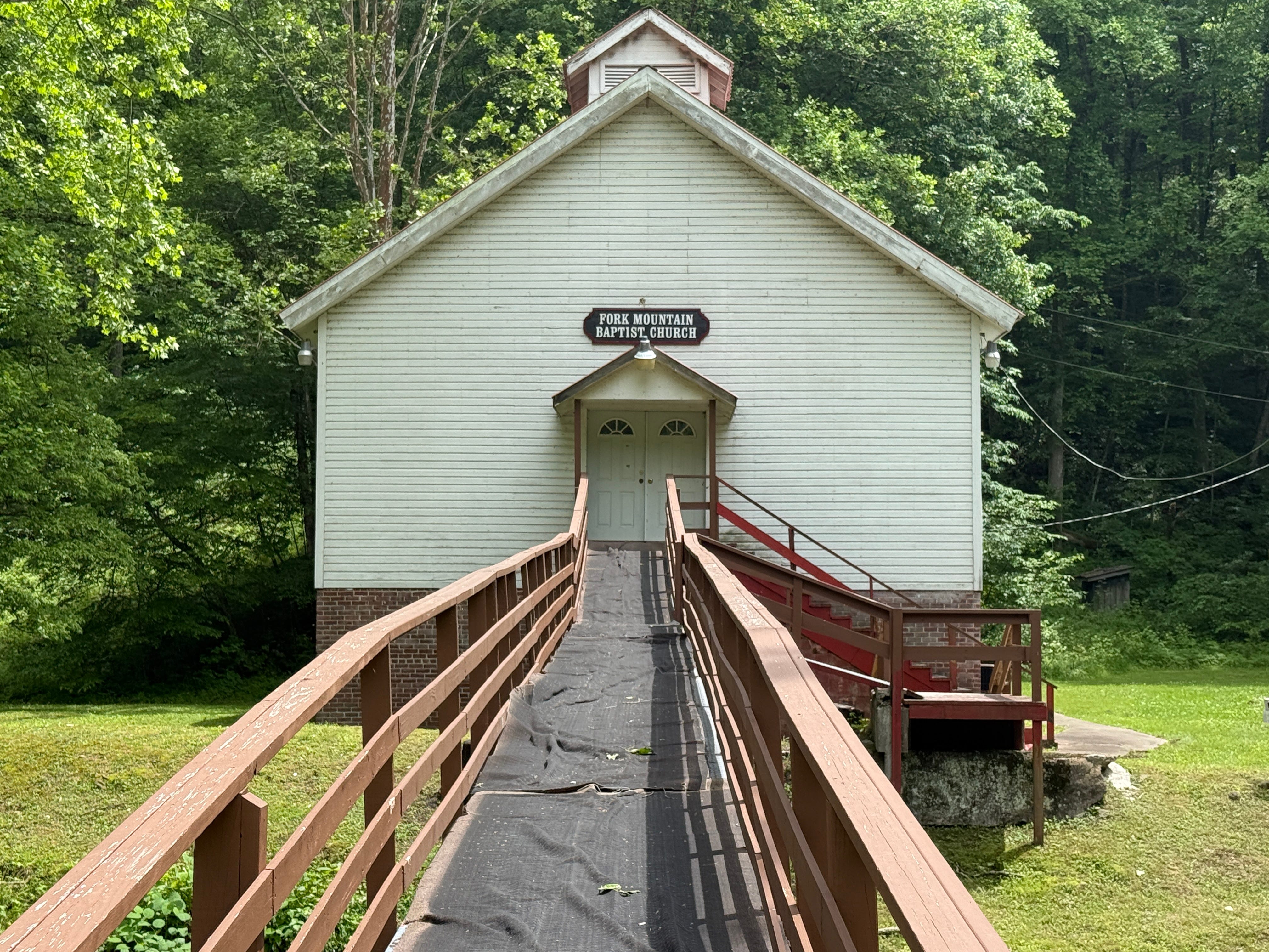
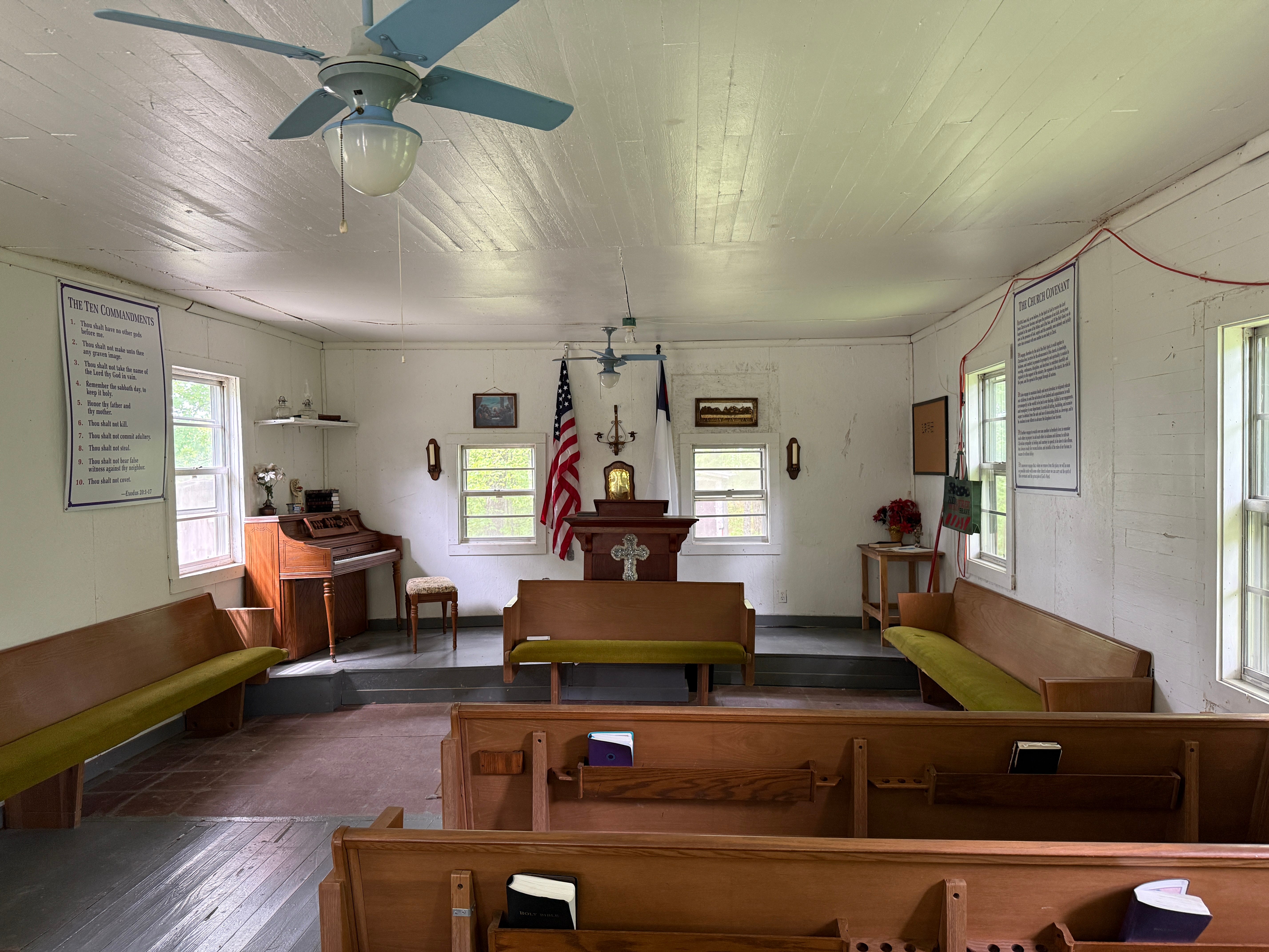
Just past the river crossing is Fork Mountain Baptist Church, this coal-mining community’s place of worship. It is unique in that parking is located on the highway, requiring worshippers to cross New River on a foot bridge to enter the church. This is a good place to stop and stretch your legs while observing what New River looks like along its upper reaches, though be careful to respect the church, which holds a worship service early on Sunday afternoons.
Down the valley: Continuing east on S.R. 116, we’ll continue our exploration of the old Fork Mountain mining community. Only half a mile past Fork Mountain Baptist Church is Beech Grove Church, another of this community’s old houses of worship. It’s located almost directly on the highway. And half a mile beyond Beech Grove Church is the Patterson Cemetery, unique because of the dozens of cross-shaped concrete grave markers that fill it.
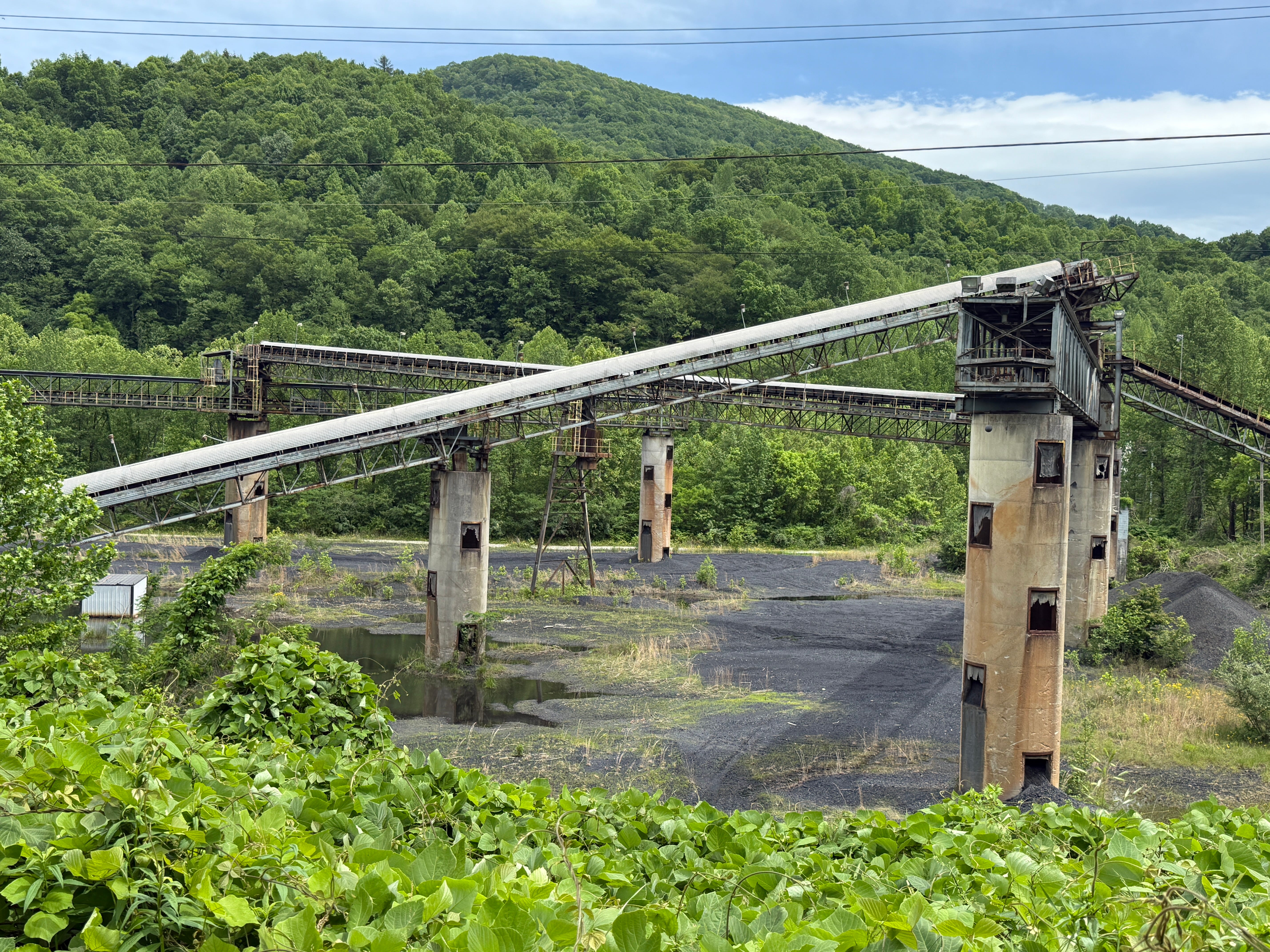
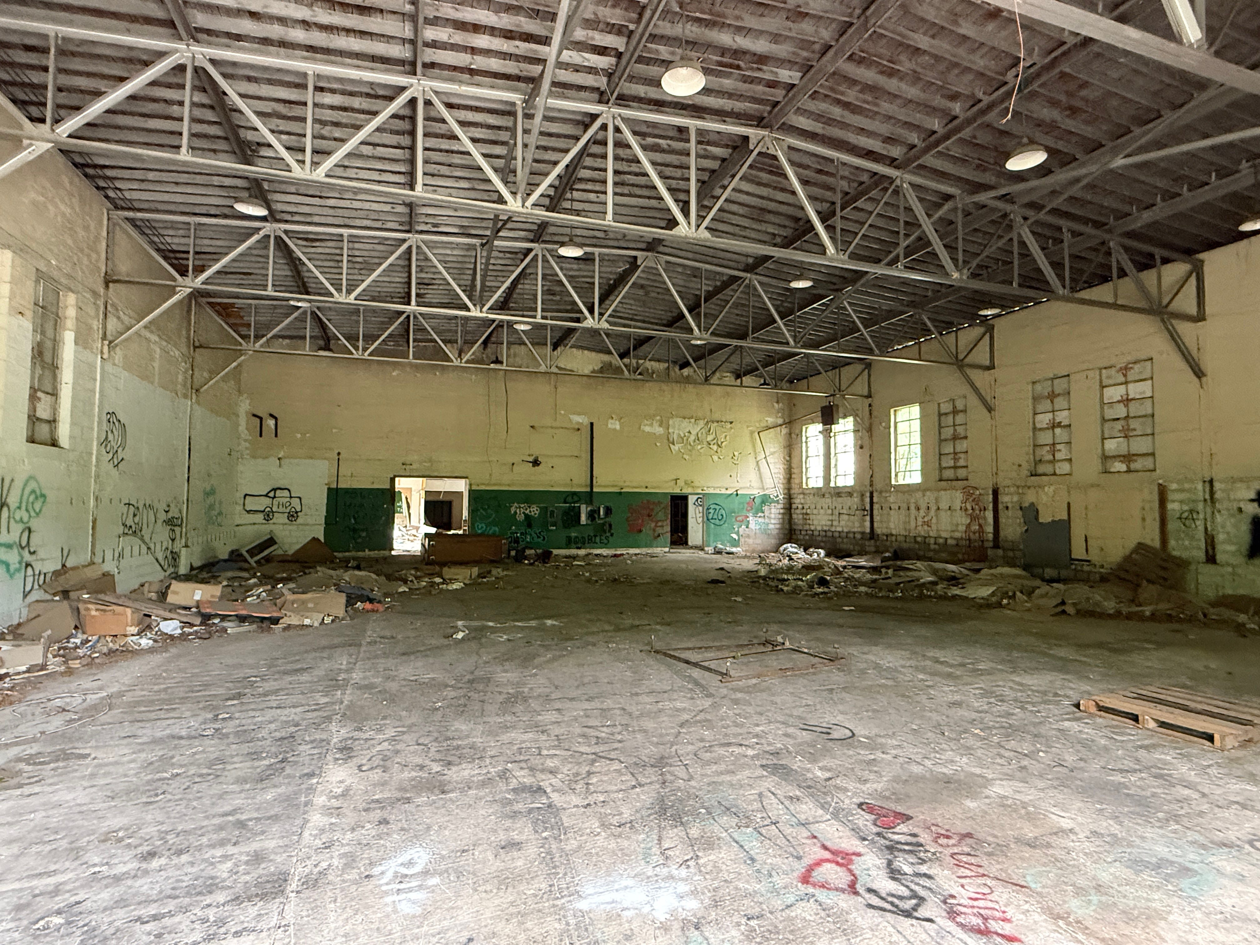
A couple of miles east of Patterson Cemetery is the old Baldwin Coal Preparation Plant. This mammoth structure was the “coal washer” used first by West Coal Company, named for Oneida coal magnate Hubert Baldwin who owned West Coal.
Baldwin began his coal mining career as a company commissary at Dean, then at Zenith. Following a deadly shootout at Zenith — which is located on North White Oak Creek in the Big South Fork National River & Recreation Area — Baldwin moved his family to Oneida, where he continued his work in the coal mining industry.
Baldwin was eventually joined by both of his sons-in-law, Roger West and Jack E. Lay, and West Coal Company was formed. At its peak, West Coal employed 1,000 people and was Tennessee’s largest mining company.
The Baldwin Coal Preparation Plant was last used by Southern Coal Corporation and today is owned by Blackstone Energy LTD. It is now abandoned, its mammoth structures being overtaken by undergrowth as it becomes a ghost town of sorts.
Behind the coal washer is the final resting place of the New River Scenic Railway Train, which was parked on a side track here after National Coal Corporation purchased the Tennessee Railroad and stopped allowing use of its rails by the excursion train in 2009. The train cars have been heavily vandalized.
About 2.7 miles beyond the Baldwin Coal Preparation Plant is the old Rosedale Elementary School. It was built in the 1950s but closed in the 1990s. Today, it is operated as Rosedale Mountain Retreat, a lodging provider targeting ATV riders.
A couple of miles beyond Rosedale School is the New River General Store, which was built in 1937 by William Lewis Coker. It is the last remaining store in this valley, and is owned by Coker’s grandson, Scotty Phillips. Phillips was one of the owners of the New River Scenic Railway. Nearby is a swinging bridge over New River — also the last of its kind in this valley.
To Red Oak: About 1.5 miles east of the New River General Store, S.R. 116 crosses New River again — now a much larger stream than when it was last crossed near the Fork Mountain Baptist Church. This is also the first glimpse of the now-defunct Tennessee Railway, which crosses the highway at this point. On the left, all the way to Oneida, the rails and timbers have been removed, leaving only a gravel rail bed. To the right, as of this writing, the tracks have yet to be removed.
To continue our journey, we’ll take a left here onto New River Road. But first we’re going to take our second side trip: to the top of the mountain and to Red Oak Baptist Church. A word of caution, though: the road up the mountain, which is on the North Cumberland Wildlife Management Area, is not well-maintained. A pickup truck, SUV or similar vehicle with some ground clearance is necessary. You don’t want to drive your sedan up this road.
To reach Red Oak Baptist Church, turn right and continue along S.R. 116 after crossing New River and the rail bed. In just a few hundred feet, Red Oak Lane turns left and begins its climb up the mountain. It’s a three-mile climb to the top of the mountain. At the very top of Red Oak Mountain, which separates the coal mining communities of Rosedale and Clinchmore, is the tiny Red Oak Baptist Church.
Seeing this small mountain church house is well worth the drive up the mountain. It’s an incredibly peaceful and beautiful setting on the mountain top. The church house was built in 1935. Prior to that, this was a school. Sadly, services are no longer held at Red Oak; as of this writing, the grounds haven’t been mowed in 2025. Still, the door to the church is unlocked, and you can slip inside and experience was houses of worship were like in these small mountain communities in days gone by.
A short stroll behind the church — beyond the matching outhouses for the ladies and gentlemen — is a small mountaintop cemetery. Buried here are Hubert Phillips, who died in 1940, his father Pharaoh Phillips, who died in 1944, and Earl Lee Bunch, who died in 2009. The Phillips family was once very prominent in the Red Oak and Stainville communities (Stainville is the name of the community at the base of the mountain, along New River). Pharaoh Phillips was part of the fourth generation of the Phillips family to live in this mountain community. His great-grandfather, Isaac Phillips, moved to the Stainville area from North Carolina in the early 1800s. Earl Lee Bunch was Pharaoh Phillips’ grandson.
After exploring the church and small cemetery on the tiny mountaintop, we’ll retrace our route three miles to the base of the mountain and S.R. 116.
Back to Scott County: When Red Oak Lane arrives back at S.R. 116, we’ll turn right and head back north a few hundred feet to the New River Bridge and the railroad crossing, where we’ll stay straight and leave the pavement of S.R. 116 as we enter New River Road, a well-maintained gravel road that continues to follow the river north.
After three miles, the gravel road arrives at the Stoney Fork community and ends at the Stoney Fork Road intersection. Turn left to continue following New River. Although not called Norma Road until it enters Scott County, this is the road that will become Norma Road and leads all the way back to S.R. 63 in the Fairview community.
After almost four miles, the road reaches the Nicks Creek community, which is located along the Scott/Campbell county line. The small community includes the Nicks Creek Missionary Baptist Church, which has been attended by several residents of the Smokey Creek and Norma areas through the years.
Another two miles past Nicks Creek is Smokey Junction, the former whistle stop on the Tennessee Railroad. There, you’ll find Hembree Grocery, where you can pick up bologna sandwiches, sodas and other refreshments — and, yes, it’s open on Sundays!
Five miles past Smokey Junction is Montgomery Junction, another whistle stop on the old railroad. A railroad spur here led up Roach Creek to the former Dean mining camp. Very little is left of the old mining community now, but you can find some old railroad ties and even a railroad bridge from the long-defunct railroad. Montgomery Road is a four-wheel-drive road that heads into the mountains. It was via this route in the early 2000s that the Tennessee Wildlife Resources Agency transported elk into the mountains and released them, beginning the elk herd that calls the Cumberland Mountains home today.
It's only 1.5 miles from Montgomery Junction to the old town of Norma. There isn’t much left of Norma today, but this was once the most populated place in Scott County, about 100 years ago when lumber was king in the New River valley. This was the home of the New River Lumber Company, and the town was known as Norcross and, before that, Skull Bone.
Although not much is left of Norma, you’ll still find the stately two-story home with the white columns that was owned by Dr. D.T. Chambers, the beloved Norma physician who was murdered in that home in the 1970s. Directly across the street is the Mountain People’s Health Councils’ Norma clinic, which is housed in the building where Dr. chambers once practiced medicine. And next-door to Chambers’ home, now surrounded by undergrowth, is the old Norma High School. You’ll also find some of the original, stately homes of Norma from the lumber company days that still stand. One of them is located on the left just past the school. Another, still in excellent condition, is the home where company president Frank Norcross himself lived. It is located on Hughett Lane, just before Dr. Chambers’ home.
Dr. Chambers’ home is today owned by Tammy Sharp Lawson. The Norcross house is owned by Leslie Byrd. The Norma School is privately owned and sadly has been heavily vandalized through the years.
Back at S.R. 63, it’s a left-hand turn and a short drive back to the 27/63 intersection in Huntsville, and the end of a journey that has taken us back in time to when coal was king in the Cumberland Mountains.
Find more photos of this Sunday Drive on our Facebook page.
Thank you for reading. Our next newsletter will be Friday Features tomorrow. If you’d like to update your subscription to add or subtract any of our newsletters, do so here. If you haven’t yet subscribed, it’s as simple as adding your email address!
◼️ Monday morning: The Daybreaker (news & the week ahead)
◼️ Tuesday: Echoes from the Past (stories of our history)
◼️ Wednesday: Threads of Life (obituaries)
◼️ Thursday evening: The Weekender (news & the weekend)
◼️ Friday: Friday Features (beyond the news)
◼️ Sunday: Varsity (a weekly sports recap)