


You’re reading “Echoes in Time,” a weekly newsletter by the Independent Herald that focuses on stories of years gone by in order to paint a portrait of Scott County and its people. “Echoes in Time” is one of six weekly newsletters published by the IH. You can adjust your subscription settings to include as many or as few of these newsletters as you want. If you aren’t a subscriber, please consider doing so. It’s free!
Today’s newsletter is sponsored by the Scott County Chamber of Commerce. Since 1954, the Scott County Chamber of Commerce has advocated for a strong community by supporting stronger infrastructure and leadership.

The slow formation of Scott County, Tennessee
Scott County was created in 1849 from portions of Campbell, Anderson, Morgan, and Fentress counties. Prior to that, residents of areas like Oneida and Huntsville were part of Campbell County, Robbins and Glenmary were part of Morgan County, and Norma and Smokey Creek were part of Anderson County. But there was a time when there was no Morgan County, no Fentress County, no Campbell County, and — while it’s debatable whether any permanent settlers lived here at the time — even no Anderson County.
Here’s a look at how it all came about.
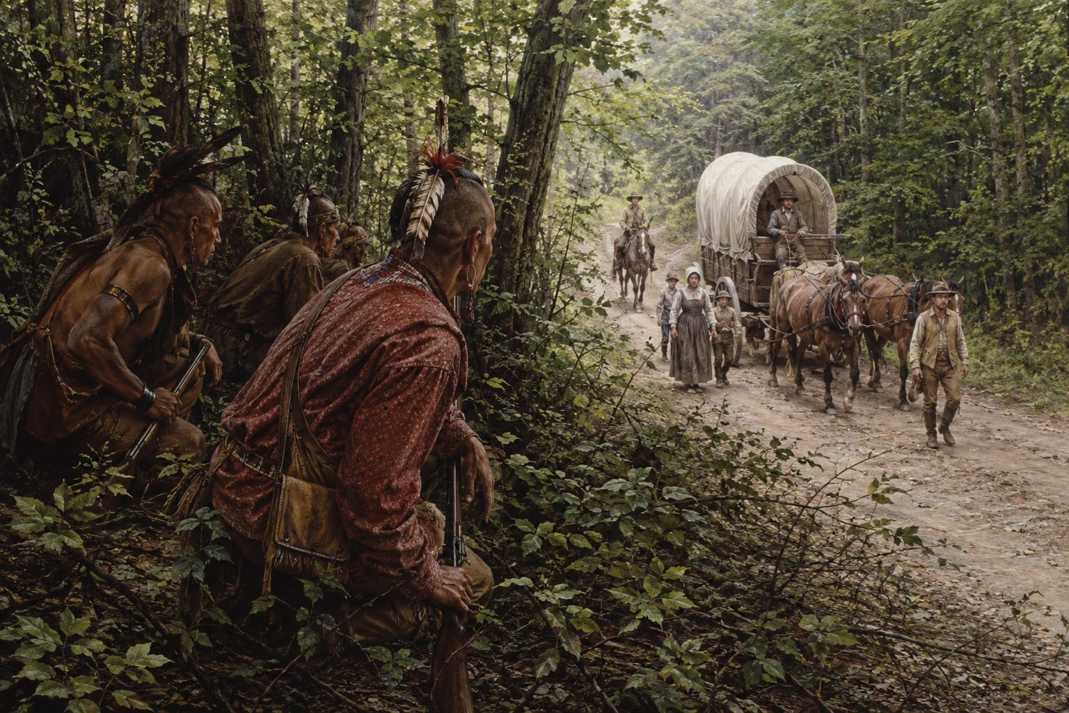
Prior to the signing of the Third Treaty of Tellico in 1805, the lands of the Cumberland Plateau belonged to the Cherokee. With the Third Treaty of Tellico, the Indians ceded ownership of the region to the U.S. government, and it was then that settlement in this area began in earnest. Were white people already living here, in Indian territory, prior to the treaty in 1805? Perhaps. It has been written that John Reed moved to New River in 1796, and there’s nothing to dispute that. The historian Esther Sharp Sanderson wrote that Mikel Low moved to Smokey Creek in 1776, but that’s almost certainly untrue (he was still living in his native Pennsylvania when he married his wife, Maria Elizabeth Bortner, in 1794).
If white people lived in the area that is now Scott County prior to 1805, settlement would have been very sparse, simply because it was not permitted by the U.S. government. In February 1804, Col. Return Jonathan Meigs — a Cherokee agent acting on behalf of the state — sent a letter to Archibald Angel and others telling them that they were “intruders on Indian Lands on the West Side of the Cumberland Mountain,” and giving them 30 days before being forcibly removed. Angel and his father-in-law — Dennis Trammell — probably hadn’t moved to the Gum Fork area east of modern-day Winfield by that time; it’s more likely that they still lived in southeastern Kentucky, where they last appeared on a tax list in 1807. Nevertheless, Col. Meigs’ letter indicates that the U.S. government was not prepared to let wholesale settlement occur on the Cumberland Plateau prior to the signing of the Third Treaty of Tellico.
In 1763, prior to the United States’ existence, when the American colonies were still part of Great Britain, King George III issued a decree declaring all lands west of the Appalachian Divide off-limits to colonial settlers. However, that didn’t mean that white folks didn’t wander here. Daniel Boone first ventured through the Cumberland Gap in 1767, and in 1772, a group of longhunters established a base camp where Charit Creek Lodge is now located in the Big South Fork National River & Recreation Area — which is now Station Camp Creek got its name. In general, the civilization pattern in this area was extended visits by longhunters in the 1760s and 1770s, before they returned to the colonies to fight in the Revolutionary War. After the war, they returned to the frontierlands west of the Appalachian Divide — this time to stay.

In 1776, the same year the Declaration of Independence was signed, the Washington District of North Carolina was created. It included all the area of present-day Tennessee. It was referred to as “Washington County” beginning in 1777. Two years later, in 1779, Virginia sent Dr. Thomas Walker and his team of surveyors to mark the latitude line of 36 degrees and 30 minutes north, which was supposed to serve as the dividing line between western North Carolina and western Virginia, west of the Appalachian Divide — areas that would eventually become Tennessee and Kentucky. When the Walker team reached the Cumberland Plateau, the terrain was so rough that they took an easier route west and guessed at where the line was supposed to go until they reached the Tennessee River near what is now Clarksville, Tennessee. As a result, part of what was supposed to be Kentucky wound up in Tennessee. If the Walker Line had been correct, the TN/KY border would be about where the Oak Grove intersection is now located in Oneida. The “Four Lane” area of Oneida would actually be in Kentucky! For much of the early 19th century, northern parts of Scott County — particularly the Big South Fork River settlements of Station Camp and No Business — were often mistakenly referred to as being part of Wayne County, Kentucky.
In 1779, Sullivan County was created from part of Washington County, as settlement began to extend into what is now East Tennessee, east of the Cumberland Plateau. In 1783, Davidson County was created in the Tennessee River basin, encompassing all of what is now the Nashville area. It was named for North Carolina General William Lee Davidson, who had been killed in the Revolutionary War in 1781. Lands to the east and west of Davidson County — including the Cumberland Plateau — were still known as Indian lands.
In 1783, Greene County was created. There were now three counties in what is now East Tennessee: Washington, Sullivan, and Greene. The Cumberland Plateau, including present-day Scott County, was still Indian land.
The year after that, in 1784, North Carolina ceded its territory west of the Appalachian Divide to the federal government as payment for Revolutionary War debts. This territory was called “The State of Franklin,” which would have been the 14th state, but it was never formally admitted into the union. It consisted of several growing white settlements in what is now East Tennessee, which were referred to as the “Overmountain Towns.” While settlement on the Cumberland Plateau did not occur prior to the Revolutionary War, it did occur in the area that became Franklin. The militiamen who won the Battle of Kings Mountain and turned the tide of the war were referred to as “Overmountain Men” because they lived “over the mountain” from North Carolina.
It was in 1785 that several new counties were created by the State of Franklin: Caswell, Sevier, Spencer, and Wilkes counties joined Washington, Sullivan, and Greene counties. Blount County was created the following year, and Hawkins was created the year after that, in 1787. That same year, Davidson County was divided in half, creating Sumner County. The Cumberland Plateau region was still Indian land.
In 1788, the State of Franklin ceased to function. As a result, all of the East Tennessee counties except Washington, Sullivan, Greene, and Hawkins went away. Davidson County was divided again, creating Tennessee County.
In 1790, North Carolina — which had reclaimed its western territory — ceded it to the federal government once and for all, and it was called the Territory South of the Ohio River, or the Southwest Territory. Tennessee was still not a state, but the territory took on the shape of the state that would soon be created. The upper east corner was divided into four counties, and the north-middle section was divided into three counties. In between, still considered Indian land, was the Cumberland Plateau.
Knox County was created, along with Jefferson County, in 1792. Two years after that, Sevier County returned, then Blount County in 1795. In 1796, Tennessee was admitted to the union as the 16th state, and Grainger and Carter counties were created, while Tennessee County west of Nashville became Montgomery and Robertson counties. Cocke County would be created the following year. The Cumberland Plateau was still Indian land.
It was in 1798 that the First Treaty of Tellico was signed and settlement began to encroach on the Cumberland Plateau. Knox, Grainger, and Blount counties were all expanded westward, and Grainger County included part of present-day Campbell County.
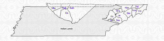
Anderson, Roane, and Claiborne counties were created in 1801. Anderson County included part of what is now Campbell County, but still did not include present-day Scott County, which remained Indian land.
In 1803, although the Cumberland Plateau was still considered Indian lands, the entire region was divided into counties. Anderson County and Roane County were greatly expanded, with Anderson County extending all the way to the TN-KY border and including what is now Campbell County. Present-day Scott County fell partially into Anderson County and partially into Jackson County. To the south was Roane County.
In 1805, the Third Treaty of Tellico was negotiated by Col. Meigs. It was signed on Oct. 25, 1805, and included 7,000 square miles of land between the Cumberland and Duck Rivers in Tennessee and Kentucky. Its purpose was to create East Tennessee with Nashville, the two areas where settlement was rapidly growing. The following year, Campbell County was created from parts of Anderson and Claiborne counties and included most of present-day Scott County. Overton County was created from Jackson County, and included the northwest part of present-day Scott County. A portion also fell into Anderson County.
Counties continued to be created in Middle Tennessee over the next several years, but it wasn’t until 1817 that change came to the northern plateau region. That was the year that Morgan County. It extended all the way to the TN-KY border. At this point, none of present-day Scott County was included in Overton County. It either fell into Campbell, Morgan, or Anderson counties — mostly in Campbell County.
Regardless of when the first settlers put down roots in present-day Scott County, we know that settlement had started by 1807, two years after the signing of the Third Treaty of Tellico and a year after Campbell County was created. It was that year that a land record was entered on New River (though it was mistakenly referred to as the Cumberland River) for Abraham Goad. He lived where the Vanderpool Farm is now located along River Road. His next-door neighbor, Randolph Lawson, had moved to the mouth of Paint Rock Creek by the following year, 1808, when he was listed as a chainman for Goad’s property survey.
The exact timing of Goad’s move to present-day Scott County has been written as 1803. There is no way to dispute that, and he last appeared on a tax list in Virginia in 1802. Meanwhile, Josiah Terry — the first settler of Oneida, along with his brother, Elijah Terry — first appeared on an Anderson County tax list in 1805. Remember that Campbell County was not created until 1806, so it’s possible — if not likely — that Josiah Terry was living in present-day Scott County by this time. He eventually built a home about where Hardee’s is located today, while his brother Elijah lived near what is now Burchfield School.
Over the next several years, between this period of 1803 to 1808 and when Morgan County was created in 1817, settlement was well underway in what is now Scott County. If they hadn’t already moved here by then, Mikel Low and Richard Harve Slaven settled Smokey Creek and No Business Creek at some point in those very early years, and Michael Robbins moved to Brimstone Creek. There were several other families arriving, as well. (See the developing narrative, The Scott County Lineage Project, on the Encyclopedia of Scott County.)
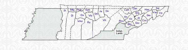
When Morgan County was created in 1817, it began to become easier to pick out where these early settlers were living. At the time, Morgan County included the western part of Scott County, including areas like Glenmary, Elgin, Robbins, and parts of West Oneida, while Campbell County included the Oneida, Buffalo and Huntsville areas, and Anderson County included the Norma and Smokey Creek areas. Parts of the Big South Fork region, like Station Camp and No Business, were sometimes considered to be part of Wayne County, Kentucky.
In 1820, the states of Tennessee and Kentucky finally reached an agreement, and the Walker Line was no longer disputed. Places like No Business, Station Camp, and Winfield were now formally part of Morgan and Campbell counties, though some confusion would remain for several more years.
Fentress County was created in 1823 from parts of Morgan and Overton counties. It now included the western part of present-day Scott County, including the Big South Fork region, while Robbins and Glenmary still fell into Morgan County.
Things remained stable for many years after that. Putnam County was created — then abolished — but that didn’t impact the areas that are now in Scott County. It wasn’t until 1849 that another change came to the northern plateau. That’s the year the legislature created Scott County from parts of Campbell, Anderson, Morgan and Fentress counties. It didn’t look quite like it does today, however. Many changes to the boundary lines would be made over the next 50 years before Scott County’s current lines were finalized.
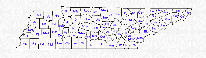
The first of those changes came in 1855, when parts of Morgan and Anderson counties were added to Scott County, and part of Scott County was added to Campbell County. It was that year that Scott County began to take on its current shape.
The last change occurred in 1920, when a portion of Scott County was added to Morgan County.
Thank you for reading. Our next newsletter will be Threads of Life tomorrow. If you’d like to update your subscription to add or subtract any of our newsletters, do so here. If you haven’t yet subscribed, it’s as simple as adding your email address!
◼️ About the IH • IH Sports Network • The Encyclopedia of Scott County
◼️ Subscribe • Sponsor • Manage Your Account
◼️ Follow us on Facebook, Instagram, X/Twitter, YouTube
Our Newsletters:
• Monday morning: The Daybreaker (news & the week ahead)
• Tuesday: Echoes from the Past (stories of our history)
• Wednesday: Threads of Life (obituaries)
• Thursday evening: The Weekender (news & the weekend)
• Friday: Friday Features (beyond the news)
• Sunday: Varsity (a weekly sports recap)