

A 'Sunday Drive' across Capachene and on to Cumberland Falls
Exploring the mountains between Winfield and Jellico where Angels, Trammells and Bairds first settled

You’re reading Friday Features, a weekly newsletter containing the Independent Herald’s feature stories — that is, stories that aren’t necessarily straight news but that provide an insightful look at our community and its people. If you’d like to adjust your subscription to include (or exclude) any of our newsletters, please do so here. If you haven’t subscribed, please consider doing so!
Today’s newsletter is sponsored by First National Bank. Since 1904, First National Bank has been a part of Scott County. First National is local people — just like you. Visit fnboneida.com or call (423) 569-8586.


Across Capachene to Bon Jellico and then to Cumberland Falls


Our first two Sunday Drives have taken us up Rock Creek and across Parkers Mountain, and over S.R. 116 and down New River — both of them drives through the heart of coal mining’s heyday in this region’s past. This week’s drive will also take us through some coal mining history — but it’s going to be a little bit different, in that we’re headed to a place so remote that almost no one lives there any longer.
It's easy to forget just how extensively coal was mined in the Cumberland Mountains and across the northern Cumberland Plateau until you start driving off the main highways … and then you see the reminders everywhere. Nearly everywhere are scars where the seams of coal were extracted from beneath the surface. Nowhere in this region, however, was the coal said to have been as pure and desirable as where we’re headed to today. Buckle up for a trip through Capachene and Jellico Creek to a place called Bon Jellico, and then on to Cumberland Falls. In all, it’s a 90-mile trip that will require about 2.5 hours to complete without stops.
To Upper Jellico Creek: A trip to Cumberland Falls after warm weather has set in is almost a rite of passage if you live anywhere in this region. But there is a much more scenic way to get there than up U.S. 27 and through Parkers Lake — by visiting the nearly forgotten remote communities in northeastern Scott County.
One word of caution: While both of the first two Sunday drives took us on portions of gravel roads, this trip will as well. But unlike the roads up Rock Creek and down New River, which are well-maintained, Capachene Creek Road is a bit rougher. It’s not a four-wheel-drive road, by any means, but you also may not prefer to take the family sedan on this trip.
From Oneida, we take U.S. 27 north to Pleasant Grove Road in Winfield. It’s about a five-mile drive from the Four Lane section of U.S. 27 in Oneida to the Pleasant Grove turnoff.
Pleasant Grove, of course, was named for Pleasant Chitwood — one of Winfield’s earliest settlers who is buried at Perkins Cemetery, which you’ll pass just about 1.5 miles off the main highway.
Pleasant Chitwood (1775-1851) was the son of Revolutionary War veteran James Chitwood (1751-1839), who moved to Winfield after the war. The Chitwood roots run deep in Winfield; so deep that this entire area was for many years known simply as “Chitwood.”
James Chitwood lived at what is now known as Pine Grove. His son, Pleasant, settled on what is now known as Pleasant Grove. Pleasant’s son, Pleasant Jr., moved deeper in the mountains, in the direction we’re headed. James Chitwood was doubtlessly attracted to Winfield because of its rich, fertile soil, and much of the bottomlands through Pleasant Grove and nearby Alderville are still farmed today.
The road through Pleasant Grove starts as a nice, two-lane, striped road that will gradually deteriorate somewhat as it heads into the Gum Fork community. The road is still paved, but the pavement is potted and broken.
To Gum Fork: About four miles off the main highway, Pleasant Grove Road leaves the fertile valley and begins to climb up and over a ridge. This ridge is attached to Chitwood Mountain, which is located just to the south and is the prominent terrain feature you notice as you look to the right.
When the road descends the opposite side of the ridge, we’ve reached the Gum Fork community. Something happens as you cross the ridge: You leave the Big South Fork watershed (which is actually referred to as the New River Watershed, if we’re being technical). Almost all of Scott County is drained by the Big South Fork River. The only exception is this tiny portion of northeastern Scott County. Specifically, the Winfield area — including Pleasant Grove — is drained by Roaring Paunch Creek, which crosses U.S. 27 and wanders north into Kentucky, past the old Barthell mining camp and eventually empties into the Big South Fork River just north of Blue Heron. Once you cross the ridge from Pleasant Grove to Gum Fork, however, the terrain is drained by Jellico Creek. We’ll be talking a lot about Jellico Creek for the remainder of this trip. The Gum Fork community is drained by Gum Fork Creek, which empties into Jellico Creek.
There isn’t much left in Gum Fork today, except for two churches (almost side by side) and the homes that are still scattered down the valley. At one point, though, this community had its own school and its own post office. The Gum Fork Post Office opened in March 1884 with George W. King serving as postmaster. It closed in September 1893 and moved to Isham. William Trammell was the last postmaster at Gum Fork.
Arriving at Angel Valley: Approximately 9.5 miles after turning off U.S. 27 onto Pleasant Grove Road, we’ll arrive at Jellico Creek. Just before you arrive at the creek, note the old, collapsing building on the right side of the road — now surrounded by new forest growth. According to Harold Chambers, who has lived in Winfield his entire life, representing the area both on Scott County Commission and on the Town of Winfield Board of Aldermen, this old building was once the community’s school. On the left, just past the ruins of the old school, is Zion Baptist Church.
Angel Valley was the name given to this fertile valley along Jellico Creek by the family that first settled here. Archibald Angel (1775-1847) married Nancy Ann Trammell, the daughter of Revolutionary War veteran Capt. Dennis Trammell, and they established a farm a mile or so down the creek from the church. (The chimney of the Angel house still stands, but you can’t see it from the main road.) Court records show that both Angel and Trammell bought land on Pine Creek in present-day Oneida in 1810, before later moving to Jellico Creek.
Archibald Angel and many other members of his family are buried at the Angel-Wright Cemetery, which is located on a knoll in the center of the old farm at Angel Valley. It is in that cemetery that the oldest identifiable headstone in Scott County is located. It is James Trammell, the son of Capt. Dennis Trammell and brother of Nancy Trammell Angel, who died in 1826.
This community, where Gum Fork Creek empties into Jellico Creek, was once known as Ketchen. Today, Ketchen Land Company — a timber company — owns about 20,000 acres in Scott and Campbell counties.
At the Jellico Creek crossing, the road splits. To the right, heading south, is Upper Jellico Creek Road. To the left, heading north, is Capachene Mountain Road. We’re headed left, but it’s worth a side trip to Upper Jellico Creek Baptist Church, which requires a right-hand turn.
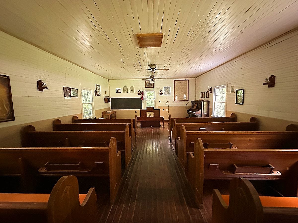
Upper Jellico Creek United Baptist Church is located 4.1 miles from the Jellico Creek bridge. The church is situated in a peaceful setting on the banks of Jellico Creek. It was founded in 1885 by Rev. Sterling Adkins (1833-1905). Adkins was born on Smokey Creek and founded the Smokey Creek Baptist Church in 1873. He spent the final years of his life at Upper Jellico Creek, and is buried in the Adkins Cemetery near the church.
Today, the doors of Upper Jellico Creek United Baptist Church are typically unlocked, offering a look inside at how rural Baptist churches once appeared. It’s a quaint church that has been carefully maintained through the years.
The Adkins Cemetery, where Rev. Sterling Adkins is buried beneath a huge poplar tree, is located at the end of a one-lane gravel road that turns off Upper Jellico Creek Road about nine-tenths of a mile before the church.
After retracing the route to the Jellico Creek Bridge, we’ll begin our drive to Capachene.
Over the mountain to Capachene: From the intersection at Ketchen, where Gum Fork Road reaches Jellico Creek, the road on down the creek is known as Capachene Mountain Road. For the first two miles, the road follows Jellico Creek. The farm on the opposite side of the creek is the old Angel Valley farm, and is one of the more picturesque farms in Scott County. The first time the fields come into clear view from Capachene Mountain Road, the wooded knoll behind the fields is where Archibald Angel is buried. Although not visible, his house was located just to the right of the wooded knoll.
After two miles, the road leaves the creek valley and begins climbing Capachene Mountain. When it reaches the top, it passes through Angel Gap and quickly begin its descent into another valley. This is Capachene Creek.
If there’s little left of Gum Fork these days and even less of Upper Jellico Creek, there’s almost nothing at all left of Capachene. It has long been visited by off-road enthusiasts more than anyone else, and the road up the creek quickly turns into a four-wheel-drive route. Only a couple of people still live at Capachene. At one time, though, this community had its own school and post office. The Capachene (sometimes spelled Capuchin) post office opened in October 1882 with Hiram Trammell serving as postmaster. It closed in May 1914 and moved to Newcomb in Campbell County.
Capachene was very much Trammell country. Remember that Revolutionary War veteran Capt. Dennis Trammell originally settled in Angel Valley with his daughter and son-in-law, Nancy and Archibald Angel. From there, the Trammells spread throughout this part of the Cumberland Mountains, and the Trammell roots remain deep throughout the Winfield area today.
Hiram Trammell (1832-1890), who was the Capachene community’s postmaster, was a grandson of Capt. Dennis Trammell. He is buried at the Trammell Cemetery just south of the road intersection where Capachene Mountain Road meets Capachene Creek. His parents, David Trammell and Lucinda Holt, are also buried at the cemetery.
Down Capachene Creek to Jellico Creek: At the intersection of Capachene Mountain Road and Capachene Creek Road, we’re going to hang a left and follow Capachene Creek into Campbell County and on into Kentucky. It’s a distance of 3.3 miles from the base of the mountain — where you find the only home you’ll encounter along this stretch of the trip, and turn left onto Capachene Creek Road — until Capuchene Creek Road ends at Whistle Creek Road in Campbell County. It seems like further, mostly because the road is a bit rough in places and forces you to drive slow. The good news is that the road improves dramatically once it reaches Whistle Creek Road.
After a left-hand turn onto Whistle Creek Road, it’s about a one-mile drive to the TN-KY state line. At that point, Whistle Creek Road becomes Jellico Creek Road — although we’re still traveling alongside Capachene Creek — and improves even more as we head further north.
This is where the real beauty of the trip begins. About a mile and a half into Kentucky, Capachene Creek empties into Jellico Creek. Soon after that, the road turns from gravel to pavement and enters a picturesque farming community that offers beautiful views of the mountains across open expanses of hay fields.
It is about a nine-mile drive from where Capachene Creek Road ends at Whistle Creek Road to Kentucky Hwy. 92.
To Bon Jellico Mountain: A few miles after turning right onto Ky. 92 towards Williamsburg, we’ll begin to climb a mountain. As we do, the peak visible to the south (right side of the highway) is Jellico Mountain. Not visible from the highway is Bon Jellico Mountain, but the highway climbs one of the ridges from the parent peak.
This was the site of some of the most sought-after coal in the Cumberland Mountains. The town of Jellico on the TN-KY border was originally called Smithburg when it was founded in 1878. The mountains around it were called the Jellico Mountains because of the species of angelica flowering plant that grows abundantly in the mountains. In the early 1880s, about the same time that coal was being discovered elsewhere in the Cumberland Mountains, it was discovered that there was an exceptionally high-quality grade of coal in these mountains, which was called the Jellico coal. It burned hot and clean, with low grades of sulfur and other impurities, making it highly sought after. As the mining industry exploded here, the town of Smithburg changed its name to Jellico to capitalize.
A separate seam of coal beneath the main vein was called blue gem coal, because of its distinctive color. It was even higher quality than the Jellico coal.
Perhaps the best-known coal mine was Bon Jellico. Bon means “good.” The Bon Jellico coal camp operated from 1912 to 1937. A total of 350 miners worked there, producing nearly 100,000 tons of blue gem coal annually. The coal was loaded onto railroad cars and moved by train to Savoy, which was located in present-day Williamsburg.
The Bon Jellico mining town consisted of 75 homes, a school and church, and a company store. Once the coal played out and the mine closed, the buildings were all destroyed.
Through Williamsburg: Just as Ky. 92 enters Williamsburg, we want to turn left onto Main Street. This will take us through the old heart of town, including the University of the Cumberlands, which was founded in 1888 by a group of Baptist ministers as the Williamsburg Institute. It changed its name to Cumberland College in the early 1900s.
Just beyond the college, Main Street crosses the Cumberland River and ends at U.S. Hwy. 25, which was once the main route between Jellico and Williamsburg before Interstate 75 was built.
To Cumberland Falls: After turning left to take U.S. 25 north, we’ll stay on Hwy. 25 for about 12 miles, until turning onto Ky. Hwy. 90 to Cumberland Falls. Take a left onto Ky. 90, and it’s a short drive through the Daniel Boone National Forest to Cumberland Falls State Resort Park.
The Daniel Boone National Forest encompasses more than 708,000 acres of land in eastern Kentucky, making it one of the largest expanses of public land in the eastern U.S. Along Ky. 90, you’ll pass Sheltowee Trace Outfitters, which offers guided whitewater rafting trips on the Big South Fork River. Sheltowee was the name the Shawnee Indians gave to Boone, meaning “Big Turtle.” Chief Blackfish adopted Boone into the Shawnee tribe in 1778.
Obviously no trip along this stretch of roadway is complete without stopping to see Cumberland Falls, affectionately known as the Niagara of the South. An interesting fact: geologists believe that the original waterfall was located about 45 miles downstream near Burnside, Ky., but erosion over time resulted in the waterfall moving upstream to its current location.
Cumberland Falls was discovered by Thomas Walker in 1750. It was Walker who was charged with leading a survey team to establish the border between Virginia colony and North Carolina colony, which would eventually serve as the boundary between Tennessee and Kentucky. When he reached this part of his journey, he got a little lazy, assuming where the line was supposed to go instead of actually surveying it, due to the rugged terrain. As a result, part of Oneida and all of Winfield were supposed to be in Kentucky, but wound up in Tennessee instead. If Walker had done his job correctly, the TN-KY line would have gone through the Oak Grove intersection in Oneida. Once Tennessee and Kentucky were granted statehood, the boundary line was disputed until the two state legislatures finally reached an agreement in the 1820s and left Walker’s assumed line in place.
Walker named the Cumberland Falls for the Duke of Cumberland and Strathearn, and it was from the waterfall that the Cumberland Mountains, the Cumberland Plateau and the Cumberland River all took their names.
In 1814, Matthew Walton and Adam Shepard — two men who served under Gen. George Washington in the Revolutionary War — surveyed Cumberland Falls and were eventually issued a land patent. In 1850, Baptist minister Lewis Renfro and his wife, Mary, became the first permanent settlers of the falls area. Their cabin was used as a hospital during the Civil War.
Socrates Owens purchased Cumberland Falls and built a hotel there in 1875.
Cumberland Falls is home to the only moonbow in the western hemisphere, which can be seen on clear nights during or near a full moon.
Cumberland Falls is home to the Moonbow Café, which serves hamburges, hot dogs, and other quick foods.
Returning Home: After leaving Cumberland Falls, we’ll continue west on Ky. 90 to Parkers Lake and U.S. Highway 27. This route is very popular among motorcycle riders during the warmer months, and you’ll see a lot of them on your drive. This is part of the Copperhead Trail, a 60-mile ride featuring 226 curves, beginning and ending in Williamsburg.
Find more photos of this Sunday Drive on our Facebook page.
Thank you for reading. Our next newsletter will be Friday Features tomorrow. If you’d like to update your subscription to add or subtract any of our newsletters, do so here. If you haven’t yet subscribed, it’s as simple as adding your email address!
◼️ Monday morning: The Daybreaker (news & the week ahead)
◼️ Tuesday: Echoes from the Past (stories of our history)
◼️ Wednesday: Threads of Life (obituaries)
◼️ Thursday evening: The Weekender (news & the weekend)
◼️ Friday: Friday Features (beyond the news)
◼️ Sunday: Varsity (a weekly sports recap)
Love the Sunday Drives series. How can I print only the Sunday drive articles? Since move to Substack I can only print too much of the feed or one page. No cell or poor cell service on much of the driving so I need a paper copy.
Enjoyed the above story! Many years ago took that Sunday after noon "drive" or journey! D W S Trammell July 1854 married my great great aunt Linzey Murphy unable too read dates.