


Cracks in the Rocks
Trailhead: Blue Heron Overlook
Trail Type: Out-and-back
Payoff: Views, rock formations
Difficulty: Moderate
Distance: 1.3 miles
Elevation Gain: 494 feet
The Spring Hiking Challenge has taken us to some pretty amazing places so far, each seemingly better than the one before: places like O&W Bridge, Yahoo Falls, Northrup Falls, and Buzzard Rock. Week #8’s destination will continue that trend. And, if we’re being completely honest, this week’s destination might be tough to beat.
We’re headed to Cracks in the Rocks this week. It is the pride and joy of the Kentucky side of the Big South Fork National River & Recreation Area, and the pride and joy of the Blue Heron Loop Trail. We aren’t hiking the entire loop; instead, we’re carving out an out-and-back adventure that takes us to the spectacular overlook and the split rock passageway below it.
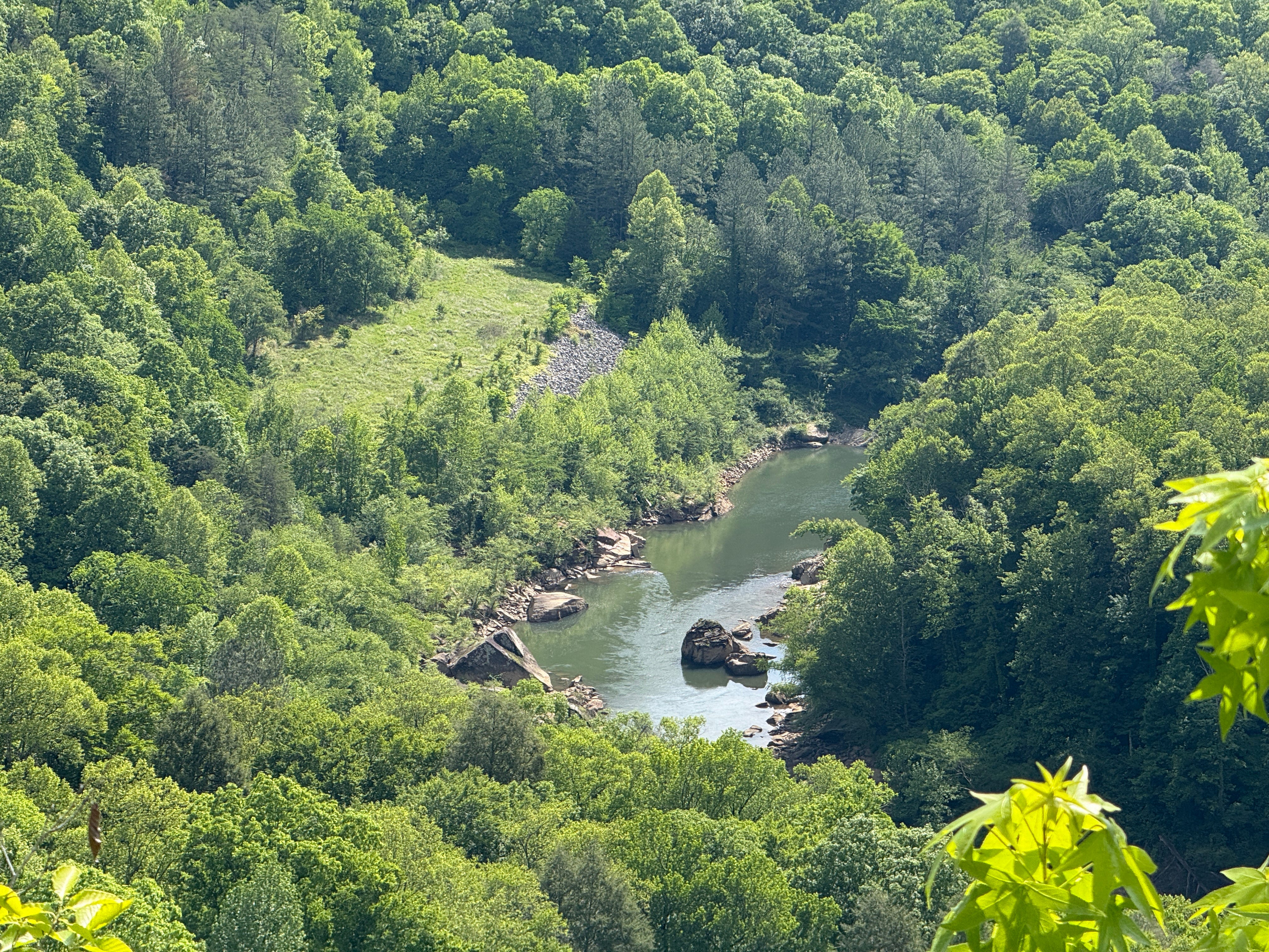
For those of us on the Tennessee side of the national park, Cracks in the Rocks — and the Blue Heron area in general — are generally underrated, simply due to a lack of awareness. The infrastructure here (paved trail access, expansive parking, restrooms, and et cetera) far surpasses East Rim Overlook or anything else on the Tennessee side of the park, and while the views offered here may not be quite the best in the BSF (respectfully, Angel Falls holds that distinction), they certainly rank towards the top. Throw in Cracks in the Rock, which rivals Twin Arches and Needle’s Eye for the most outstanding geological formations in the BSF, and Blue Heron is a can’t-miss destination that everyone should experience … especially when the mountain laurel is in bloom, as it is now.
Step-for-step, there’s no question that this week’s hike is the most difficult one thus far. However, we’ve intentionally shortened it so that it will still be kid-friendly and a hike the entire family can enjoy. At 1.3 miles, it’s one of the shortest hikes of the challenge so far.
The challenge apologizes for back-to-back trips to the Kentucky side of the park, but we wanted to catch the mountain laurel while it’s still in bloom, because it grows in abundance along the route to Cracks in the Rocks. While we’re headed to the north end of the BSF, we aren’t headed as far north as Buzzard Rock or even Yahoo Falls.
So, for the third and final time of the Spring Hiking Challenge, let’s head north across the state line!


To get to the trailhead, head north on U.S. Highway 27 into Kentucky. (If you want to take the scenic route, turn onto Kingtown Road in Winfield and go that way, which adds about 10 minutes to the trip.) At Stearns, turn left onto Ky. Hwy. 92 (towards McCreary Central High School), and take it 1.3 miles to Revelo. There, veer left onto Ky. Hwy. 1651, and after half a mile take a right onto Ky. Highway 741. After seven-tenths of a mile, turn right again onto Mine 18 Road, and follow it 5.9 miles to Gorge Overlook Road, which will be on the left after entering the Big South Fork National River & Recreation Area (if not using a GPS or maps app, watch for the sign). Continue to the end of the road, which ends in a loop at a large parking area.
There are actually two overlooks here: Devils Jump Overlook and Blue Heron Overlook. Devils Jump is definitely the most spectacular of the two, and you owe it to yourself to check it out while you’re here (more on that in a bit). For the purposes of this hike, though, we’re going to start at the end of the road and visit only Blue Heron Overlook.

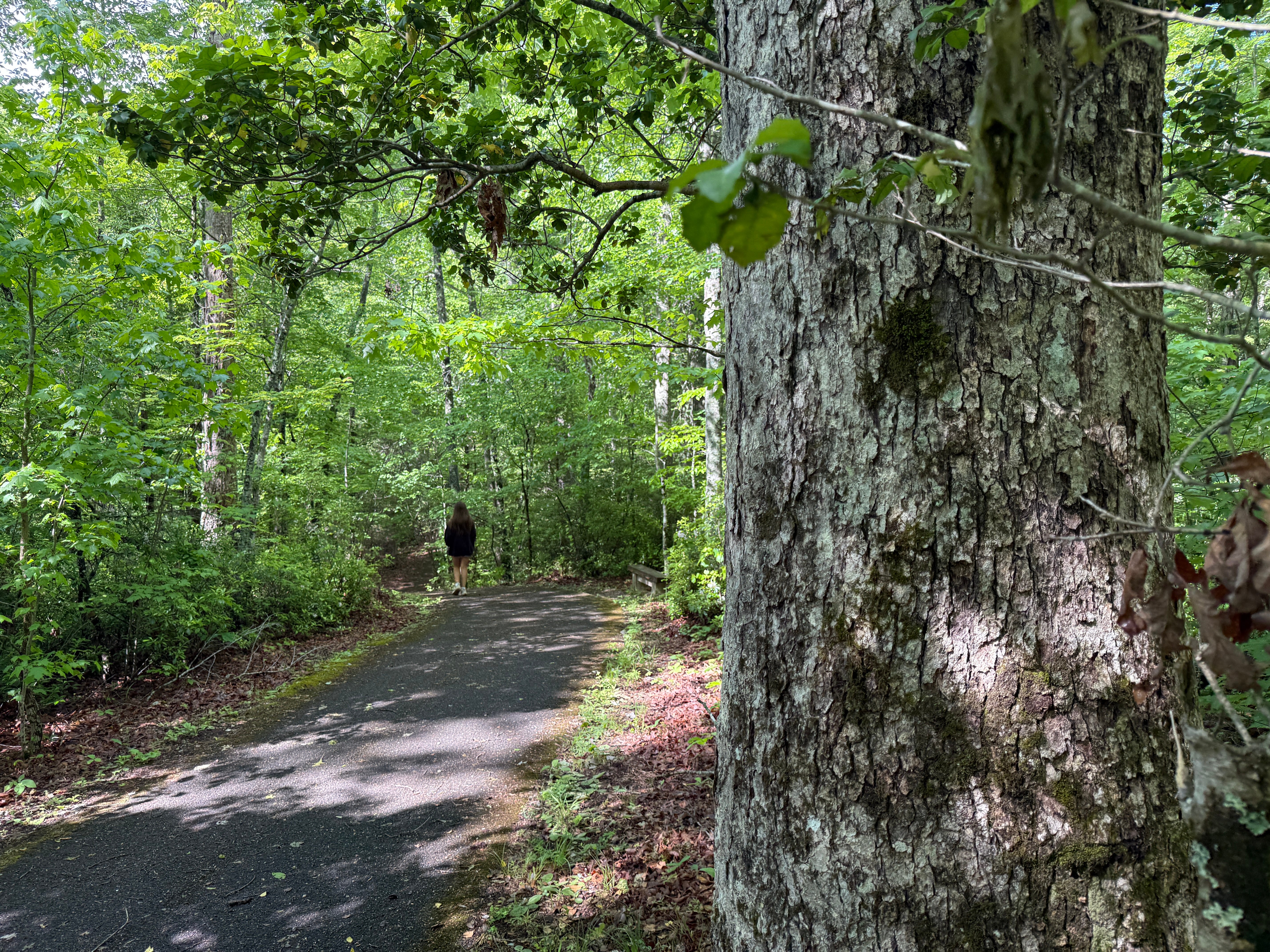
Mile 0.0: From the parking lot, the trail is a wide, paved, handicap-accessible pathway all the way to the overlook. It ventures through a lush, mixed-hardwood forest that features oak, hickory and maple, with a sparse scattering of hemlock and an understory of mountain laurel and various other shrubs.
Mile 0.12: Check out the large oak tree on the right side of the trail. By Big South Fork standards, this tree is pretty massive. Most of the older oak and other hardwoods were cut by timber-cutters in the early and mid 20th century, before the land was acquired by the federal government. This land was once owned by the Stearns Coal & Lumber Company, which did the bulk of the timber-cutting.
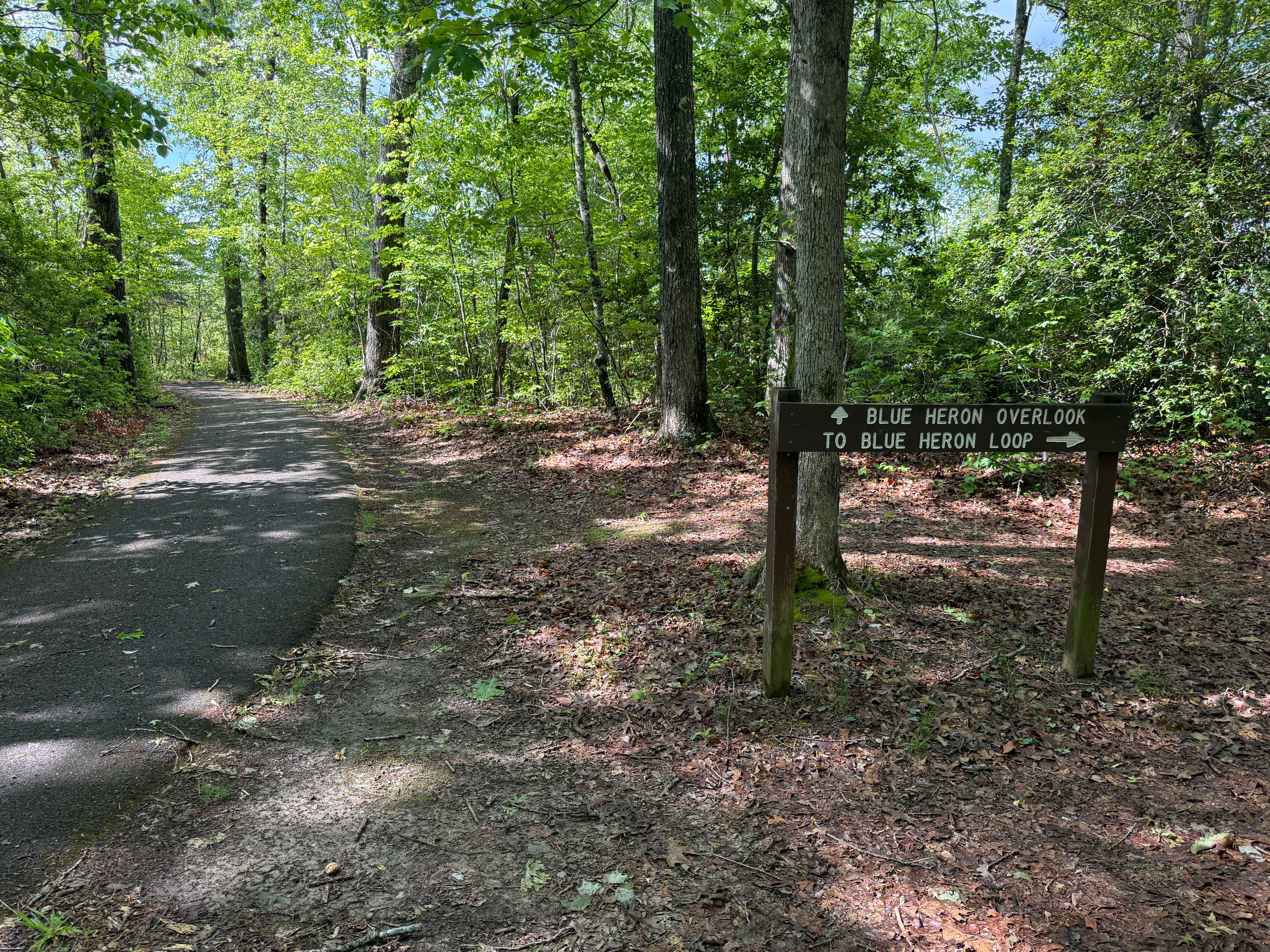
Mile 0.20: The trail splits, with the dirt right fork leading to Blue Heron Loop, and the paved main trail continuing to the overlook. We’re going to stay left and visit the overlook. The forest type changes dramatically here, as it nears the rim of the gorge and the mature hardwoods give way to scrubby trees and shrubs that define the sandy, shallow, and well-drained soils near the edge of the gorge.
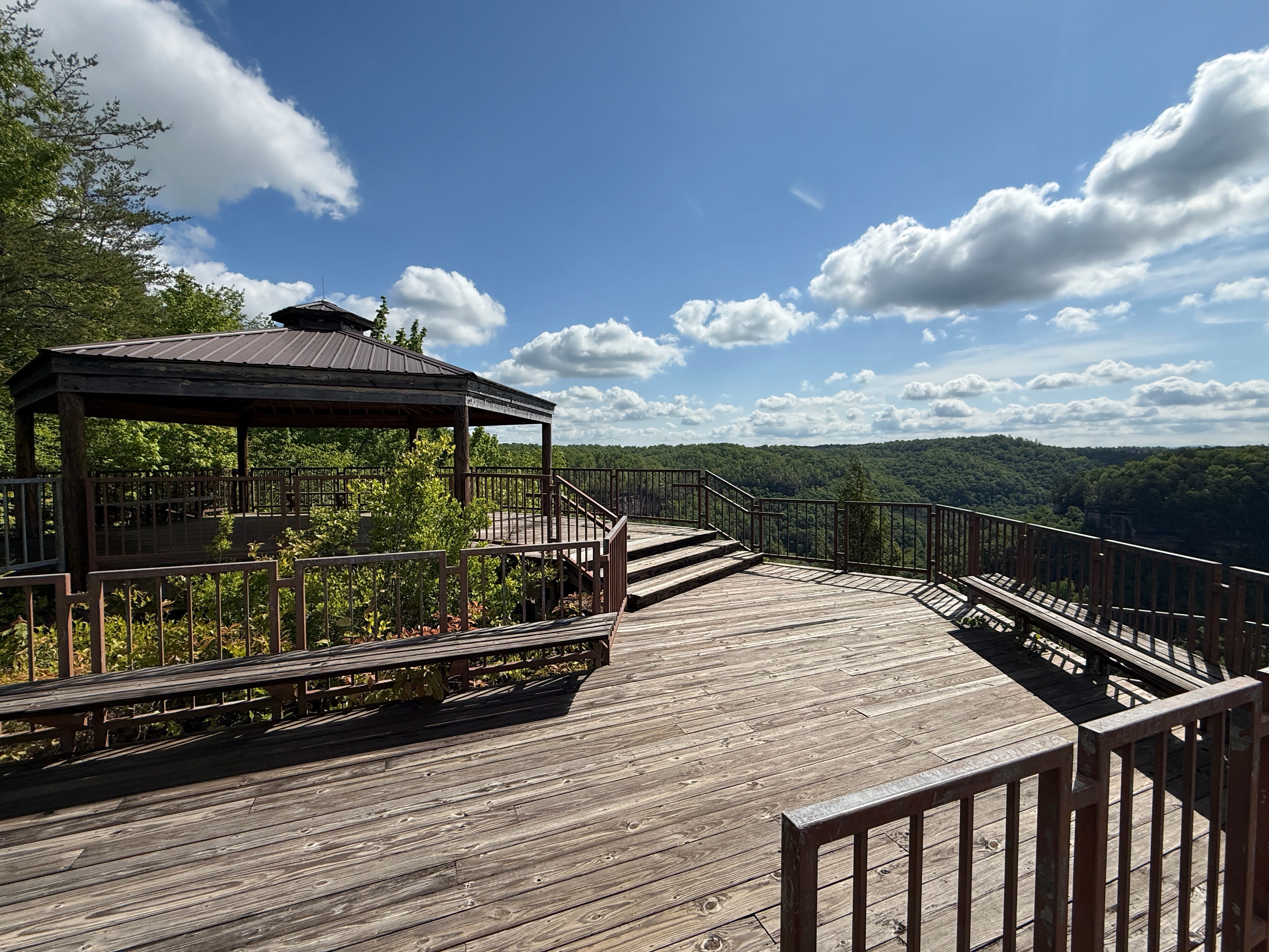
Mile 0.25: The trail reaches the overlook, which offers an expansive view of the Big South Fork River. To the left, you can see a reclaimed strip mine near the river’s edge. Also to the left, you can see the viewing platform at Devils Jump Overlook. The platform here is massive, and it’s the only place in the BSF where there’s a roofed vantage point that allows you to admire the views from an overlook on a rainy day and stay dry, if you so desire.
From the overlook, we backtrack to the fork in the trail.
Mile 0.34: Take the left fork at the split, leaving the pavement and turning onto the narrow, dirt trail that leads to Blue Heron Loop. The trail will lead slightly downhill as it makes its way from the tabletop plateau lands to the bottom of the cap rock that lines the rim of the gorge.
Mile 0.40: The trail gets a little steeper as the real descent starts.
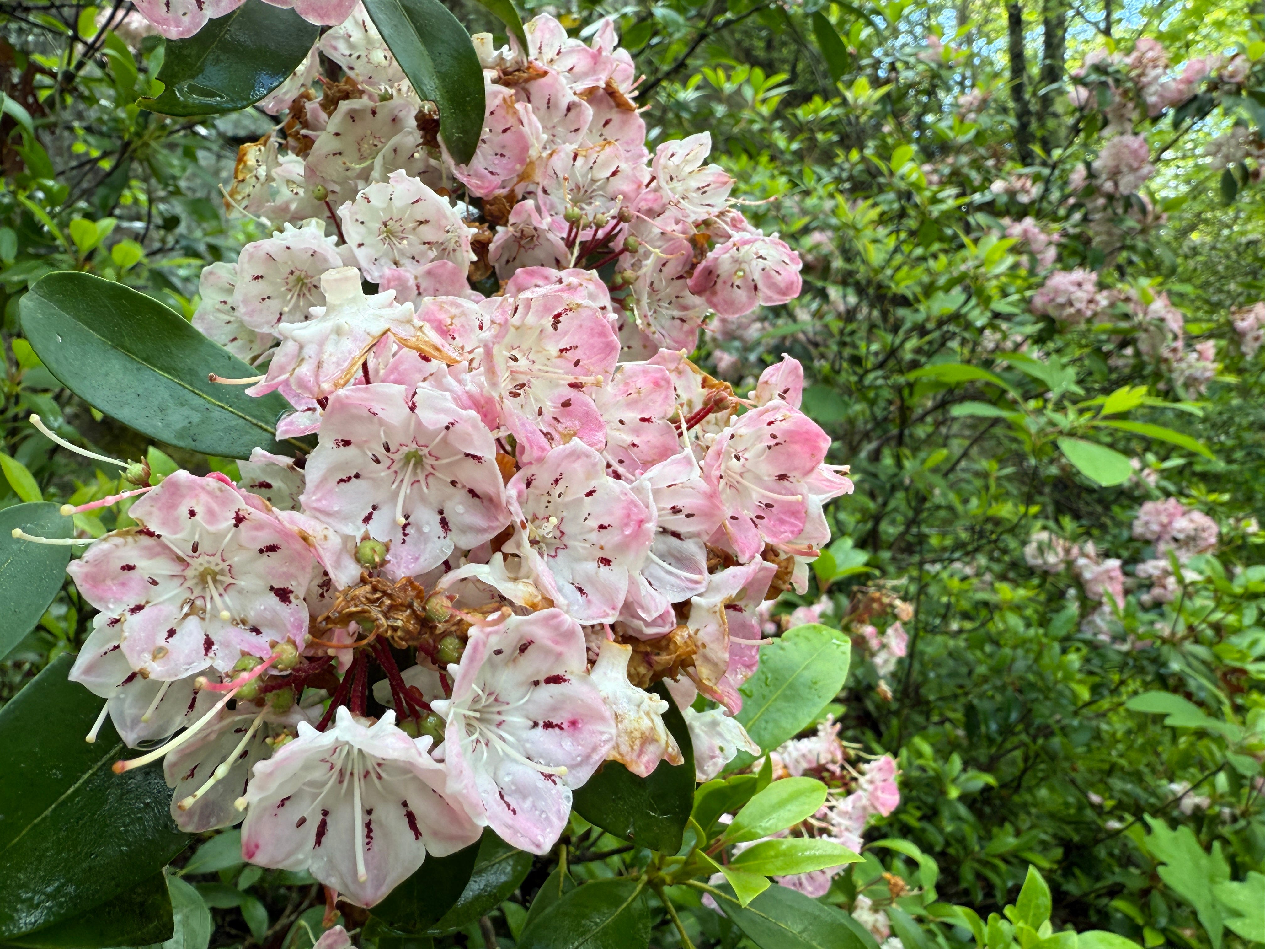
Mile 0.45: If you’re fortunate enough to hike this trail on schedule, while the mountain laurel is still blooming (we’re nearing the end of the blooming season), check out the stunning pink laurel to your left. Most of the mountain laurel in the BSF has white flowers that are outlined in pink. Occasionally, though, you’ll come across the more colorful varieties, like this one.
Mile 0.46: The trail intersects with the actual Blue Heron Loop Trail. Turn right.
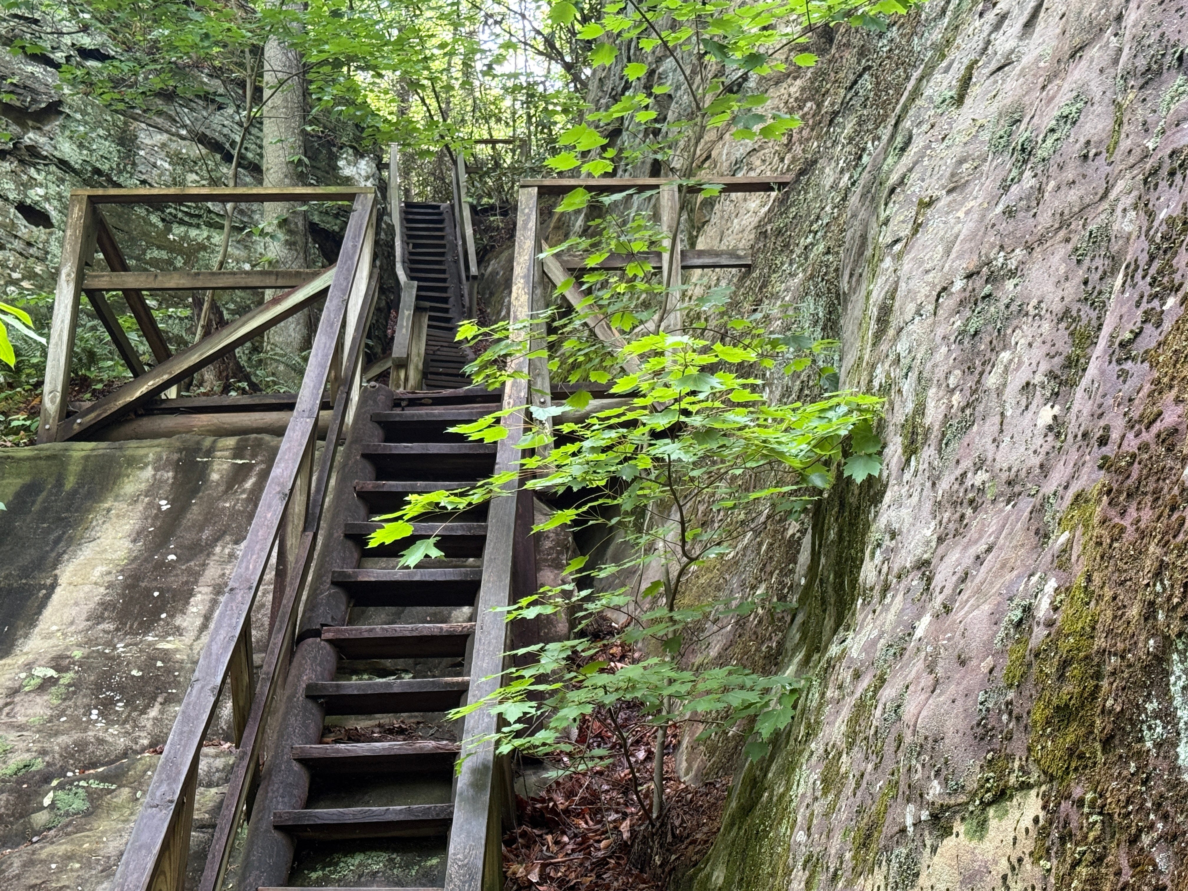
Mile 0.53: The trail descends a steep set of steps to reach the bottom of the bluff line.
Mile 0.59: There’s an unsigned fork in the trail. The right fork dead-ends at a rock shelter. Stay left to continue to the destination.
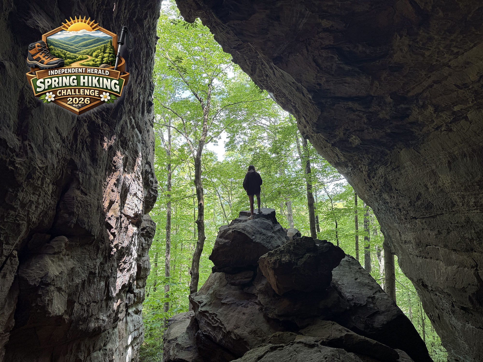
Mile 0.63: Check out the towering rock wall along the left side of the trail. It is a fissure through this same rock wall that offers the passageway known as Cracks in the Rocks.


Mile 0.66: Arrive at Cracks in the Rocks. This series of “cracks,” or fissures, through the massive rock lining the gorge rim has been created by time and erosion. The trail enters and exits the passageway via two sets of steps. This is one of the most stunning geological formations in the Big South Fork, competing with points of interest like Twin Arches, Needle’s Eye, and Devils Cave for that unique honor. After exploring the natural passageway through the rock, we’ll retrace our steps to the trailhead.
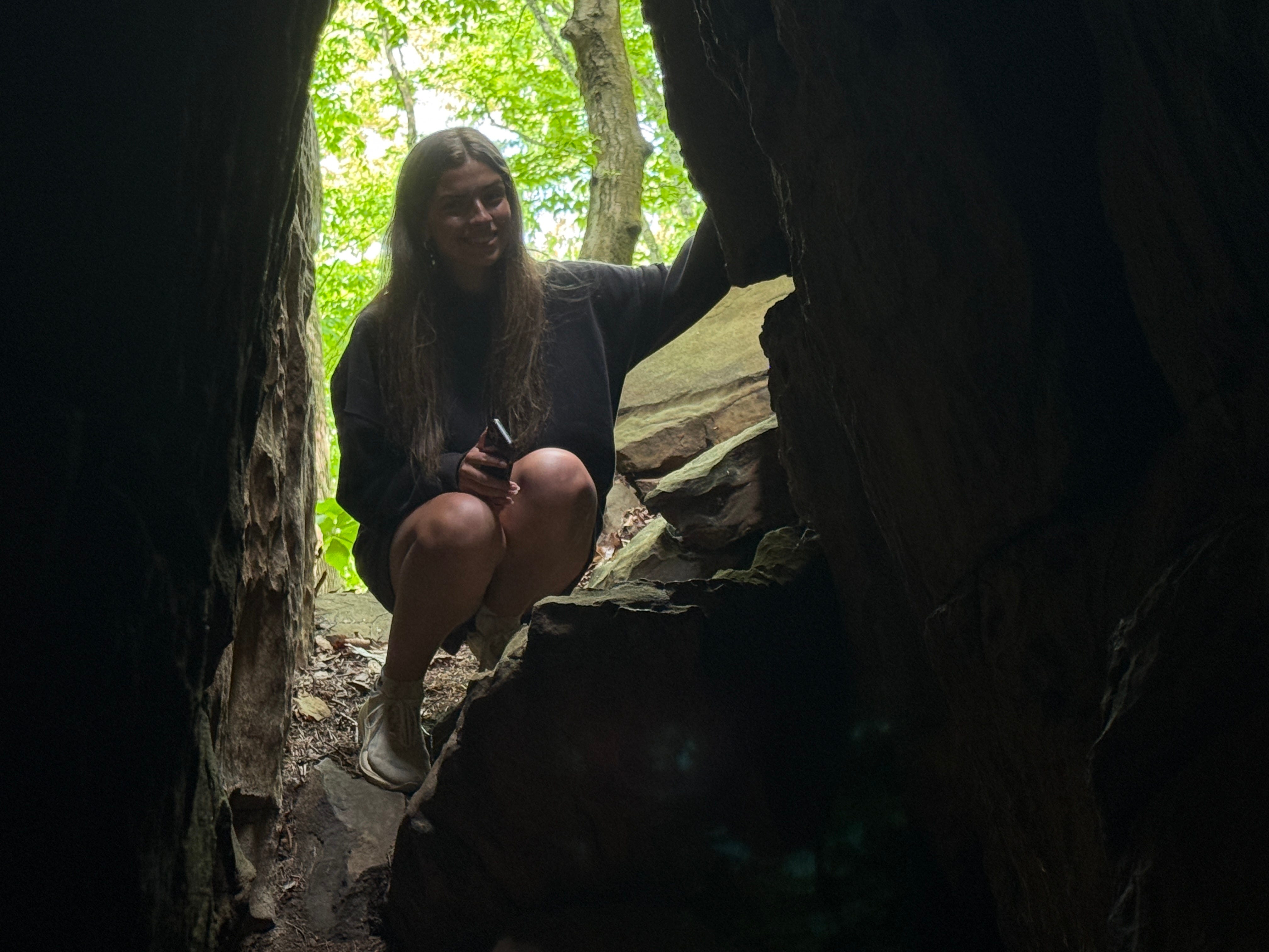
Scavenger Hunt: There is a main way in and a main way out of Cracks in the Rocks. But if you stoop low enough, you’ll find a “secret” exit near the base of the stairs. Take a picture of this hidden passageway and post it on social media with the hashtag #SpringHikingChallenge to enter our random drawing for a Texas Roadhouse gift card.
Historical Context: Blue Heron was an isolated mining camp on the Big South Fork River that was operated by the Stearns Coal & Lumber Company from 1937 to 1962. It was the site of the company’s Mine #18, and it was served by the Kentucky & Tennessee Railroad, which still offers excursion trips to the historic mining community today. As a company town, Blue Heron was complete with workers’ houses, a store, and related infrastructure. There was also a coal tipple, where coal was loaded onto railroad cars. After the mine closed in 1962, the buildings all decayed or were removed. In the 1980s, the National Park Service rebuilt many of the structures as open-air steel skeletons or “ghost structures” to show the original size and locations of homes, the church, and the school. The coal tipple was also restored. Today, Blue Heron tells the stories of the life that once happened in this isolated, yet vibrant community.
Make It Better: We’re starting this week’s hike from the Blue Heron Overlook Trailhead to shave off some distance, but there are several ways to make this trip better. A.) Begin your hike at the first parking lot on the left after turning from Mine 18 Road onto Gorge Overlook Road, which is the trailhead for Devils Jump Overlook. From there, you can hike to Blue Heron Overlook and Cracks in the Rocks. It’s a 1.8-mile out-and-back hike (not including the climb from the loop trail up to Blue Heron Overlook) and includes a visit to Devils Jump Overlook. B.) Begin your hike at either starting point and finish the entire Blue Heron Loop. From Cracks in the Rock, simply continue along the trail rather than retracing your steps back to the trailhead. You’ll go to the historic Blue Heron mining community, follow the river for a short distance, then climb back to the top. It’s a 7-mile hike featuring about 980 feet of elevation gain. C.) If you don’t want to add any mileage to your hike, finish your trip to Blue Heron by driving back to the Devils Jump Overlook parking lot and visiting the overlook, which is just a short walk from the trailhead, and/or take Mine 18 Road on to the Blue Heron mining community and explore it while staying within sight of your vehicle.
Be Careful For: There are steep steps on this hike. Use caution with pets and small children. Use extra caution if the stamps are damp or wet, as they can become slick.
Please Remember: Hikers are encouraged to obey the “Leave No Trace” ethic. “Leave only footprints, take only memories.” Please do not litter! Also, remember that while all trails in the Big South Fork are dog-friendly, all dogs must be leashed and kept within six feet.
Document Your Hike: Record your participation on this week’s hike by taking a photo of you and your group and tagging it with the #SpringHikingChallenge hashtag on social media (make sure the post privacy is set to public!) or emailing newsroom@ihoneida.com.
Hike #1: Sunset Overlook
Hike #2: Angel Falls Rapid
Hike #3: Yahoo Falls
Hike #4: O&W Bridge
Hike #5: Northrup Falls
Hike #6: Burnt Mill
Hike #7: Buzzard Rock